Chuck Hill's CG Blog

Chuck Hill's CG Blog

Why Russia Should be Worried, “ARCTIC PRC’s 13th Arctic expedition creating concerns for Russia” –The Watch

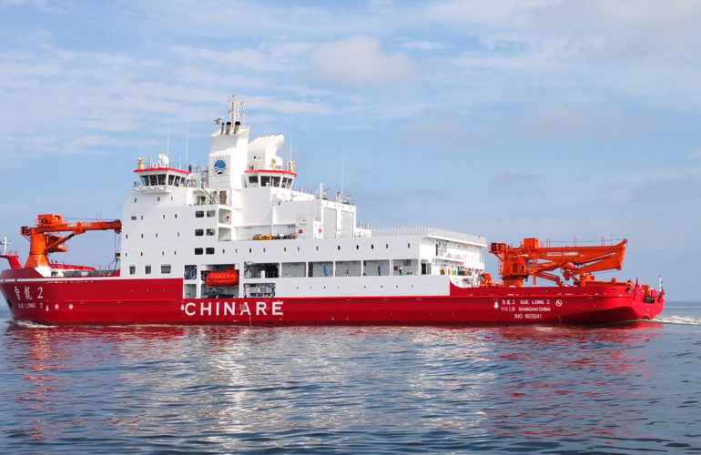
Xue Long 2 on sea trials. Photo by PRIC.

NORTHCOM’s online magazine, “The Watch,” gives us a balanced, non-alarmist, look at Chinese Arctic activity, but also tells us why maybe Russia should be worried.

I have contended for a long time that sometime in the future, China will turn on Russia and recover those parts of China ceded to Russia as a result of unequal treaties (and here) in the 19th Century, during what China calls the Century of Humiliation, and while they are at it, maybe a bit more. They have neither forgotten nor forgiven.  

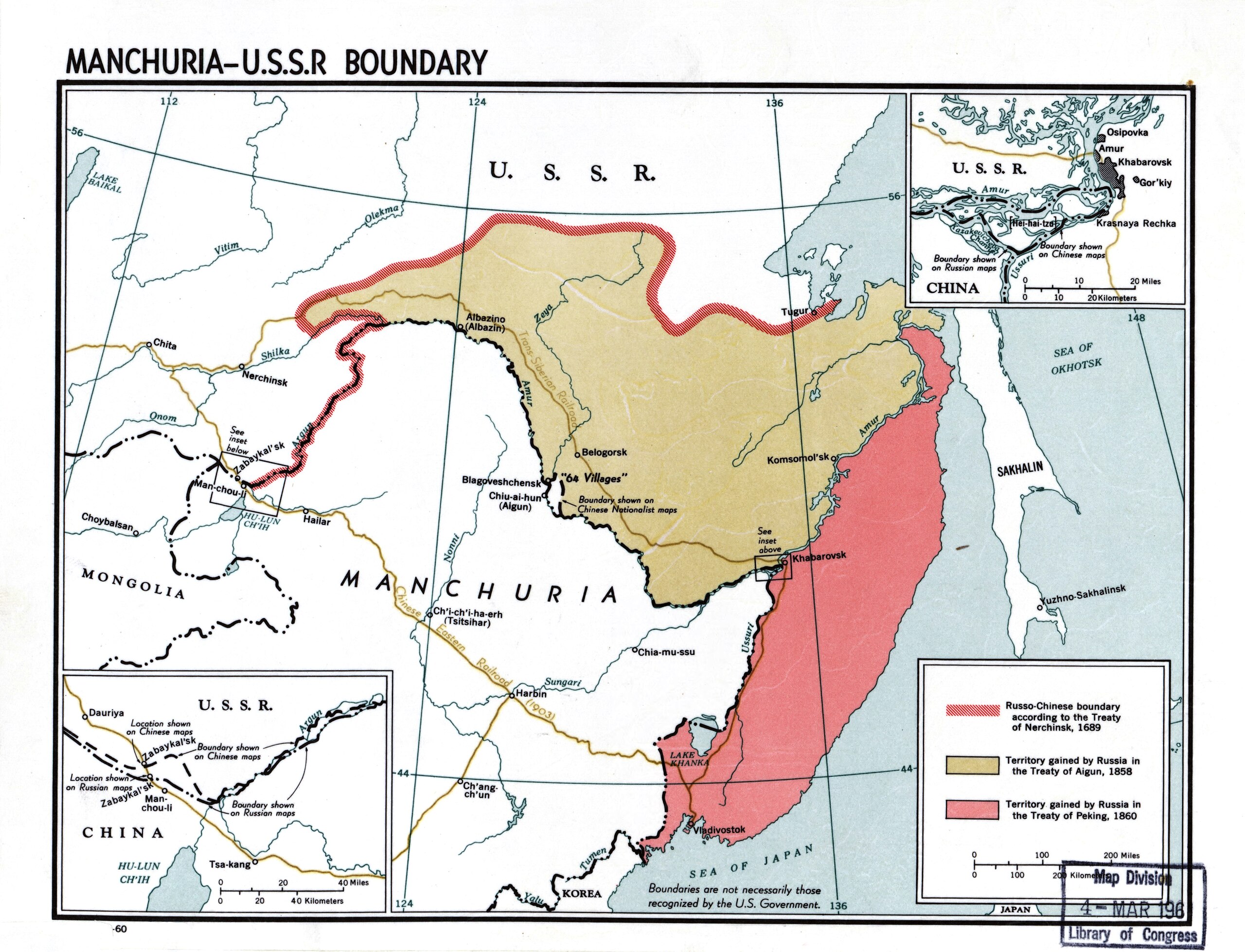
Library of Congress Geography and Map Division Washington, D.C. 20540-4650 USA
DIGITAL ID g7822m ct002999 http://hdl.loc.gov/loc.gmd/g7822m.ct002999

China and Russia have a long history of conflict (here, here, here and here), There was a border conflict between China and Russia (then the Soviet Union) in 1969, when China was clearly the weaker of the two, that lead to China opening to the West and Nixon’s trip to China.

Russia and China’s current partnership has mostly benefited China. China benefited from technology transfers and reverse engineered Soviet and Russian weapon systems.

Now China is clearly stronger than Russia in just about everything except nuclear weapons, and they are now rapidly growing their nuclear capability.

If China should decide retaking Taiwan, which has 215,000 active military and 2,310,000 reservists, a tech savvy population of about 24 million, and is protected by the 100-mile-wide Taiwan Strait and has potential help from powerful allies, may be too risky, they may decide recovery of Outer Manchuria is a good consolation prize.

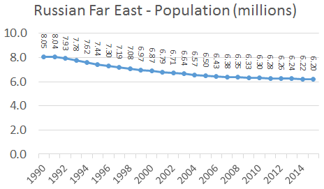
Population of the Russian Far East, 1990-2015 Data source: Fedstat. Author: Underlying lk. (About four million of these live in former Chinese territory.)

The Russian population in the Far East is small and declining. Russian infrastructure connecting industrialized European Russia with the FarEast is weak. Most of the Russian military is in Europe, and their weakness has been exposed in Ukraine.

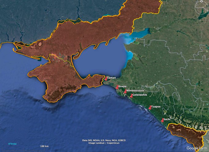
If China attempted to retake land formerly part of China, they would want to cut Russia’s East/West logistics links. Taking out the few railroad links using airpower would be relatively easy. Air links can’t carry much in the way of heavy equipment. Most Russian supplies and material reinforcements would have to come by sea. Even if the Chinese did not interdict Russian traffic on the Norther Sea Route as suggested in the linked post, China’s Navy and Air Force could dominate Russian access to the Sea of Japan, including the primary Russian Pacific Fleet base in Vladivostok. Chinese submarines and their rapidly expanding force of aircraft carriers could probably cut off access to the Sea of Okhotsk and Petropavlovsk.

From a Chinese point of view recovery would be justified and perhaps far less costly than an amphibious invasion of Taiwan.

If the Russians can be made to see the righting on the wall, they might even be willing to sell the territory back to their friend at wholesale.

“US Coast Guard cutter provides presence during Russian military exercise in Bering Sea ” –D17

U.S. Coast Guard Cutters Stratton (WMSL 752) and Kimball (WMSL 756) steam in formation while patrolling the U.S.-Russian Maritime Boundary Line (MBL), in the Bering Sea, Sept. 26, 2022. This marked the first time two national security cutters jointly patrolled the MBL above the Arctic Circle. (U.S. Coast Guard courtesy photo).

Below is a District 17 (Alaska) News Release

Sept. 18, 2023

US Coast Guard cutter provides presence during Russian military exercise in Bering Sea

D17 Public Affairs

JUNEAU, Alaska – The crew of Coast Guard Cutter Kimball (WMSL 756), in coordination with U.S. Northern Command, provided U.S. presence during a Russian military exercise in the Bering Sea, Friday.

The Kimball patrolled in the vicinity of U.S. fishing vessels conducting their work in international waters within the U.S. exclusive economic zone (EEZ) during ongoing Russian military operations, which included the launch of a missile, approximately 300 miles southwest of St. Lawrence Island.

“Though military operations and exercises in international waters are lawful,” said Rear Adm. Megan Dean, Seventeenth Coast Guard District commander, “we will continue to ensure there are no disruptions to U.S. interests or commerce in the maritime environment around Alaska.”

On Sept. 10, an urgent warning of navigational dangers advisory message, known as a HYDROPAC, was released through the National Geospatial Agency regarding Russian military operations in the Bering Sea. The area of the HYDROPAC includes a portion of the U.S. EEZ southwest of St. Lawrence Island along the U.S./Russia Maritime Boundary Line and remains in effect through Sept. 24.

The Coast Guard notified vessels and the commercial fishing industry operating in the vicinity of the HYDROPAC, and made notifications to federal, state and tribal governments about the exercise. The Coast Guard continues to provide notifications throughout the maritime and fishing industry by all available means.

The Kimball, a 418-foot legend-class national security cutter homeported in Honolulu, Hawaii, is currently operating under the Seventeenth District’s Operation Frontier Sentinel.

Operation Frontier Sentinel is a Seventeenth Coast Guard District operation designed to meet presence with presence and ensure there are no disruptions to U.S. interests in the Alaskan maritime environment. The Coast Guard routinely patrols international waters under the service’s statutory authorities to ensure maritime safety and security of the U.S. maritime industry, to protect U.S. sovereign rights and to promote international rules-based order. Coast Guard presence ensures due regard for all lawful uses of the seas.

“US Coast Guard Icebreaker Sails in Proximity to Russia’s Northern Sea Route” –High North News

Nansen and Amundsen Basins Observational System (NABOS) moorings Healy is expected to visit. (Source: UAF)

High North News reports,

The US Coast Guard icebreaker Healy finds itself in unfamiliar waters as it becomes the first US government surface ship to venture into proximity of Russia’s Northern Sea Route (NSR) in the East Siberian Sea in several decades.

Russia claims the right to regulate traffic along the Northern Sea Route, a right the US does not recognize.

Healy is engaged in support of scientific research, but the Russians may view it as a challenge to their regulatory regime. The voyage, which originated in Seattle will end in Norway. Of course, Healy will then have to return to the US.

It is likely the US would like to do a Freedom of Navigation Operation through the Northern Sea route, but we have not had the facilities to do it with confidence.

Intentionally or not, Healy may be dipping a toe into the Northern Sea Route. So far, the Coast Guard is not saying.

Check out the article for a more complete discussion.

Thanks to Tups for bringing this to my attention.

“Southern Command: Russia disperses ships in fear of Ukrainian strikes” –Kyiv Independent

A map showing the location of the Black Sea and some of the large or prominent ports around it. The Sea of Azov and Sea of Marmara are also labelled. Created by User:NormanEinstein, Wikipedia

Kyiv Independent reports,

Russia has dispersed its naval forces in the Black Sea between the southeastern coast of Crimea and Novorossiysk in fear of Ukrainian surface drone strikes, Southern Command spokesperson Natalia Humeniuk said on Aug. 18.

Well, the US Navy is all a twitter about “Distributed Maritime Operations” (DMO) so is this a good idea for the Russian Black Sea Fleet? Like most such questions, it depends.

It depends on how good Ukrainian intelligence is. The supposed advantage for the Russian Fleet would be that their ships are harder to find, but is this case? Not only does Ukraine have access to some Western intelligence sources, but they seem to have good independent intelligence. All their successful USV attacks seem to have been against valid targets though there are many more potential targets that were not directly supporting the Russian military. When Russian ships are in port, the Ukrainians are going to know it.

Convoying has been a feature of Naval Warfare for over a thousand years because it is a defensive tactic that takes the choice of where and when to concentrate out of the hands of the offense. Spreading out the potential targets requires diluting the defense. That leaves the choice of where and when to concentrate effort in the hands of the Ukrainians.

To be successful, the defense has to detect all of the incoming USVs at a distance from their target and have sufficient numbers of countermeasures systems, in the right place, to engage all incoming USVs as they are detected.

The Ukrainian USVs don’t seem to be too hard to defeat once they are detected. Most of the successful countermeasures seem to have used machineguns, but you need one or more within effective range to engage every attacking USV.

The Ukrainians have told the world that no Russian Black Sea port is safe.

On August 4, Ukraine’s maritime authorities issued a “war risk area warning” to all international mariners headed for six Russian Black Sea ports, including Novorossiysk and the smaller oil-exporting terminals of Tuapse and Taman. The warning is scheduled to go into effect on August 23 and continue “until further notice” (Interfax-Ukraine, August 5). And on August 8, Zelenskyy’s economic adviser Oleh Ustenko told US media that “everything the Russians are moving back and forth on the Black Sea are our valid military targets,” including oil tankers or terminals.

When you multiply the number of points you have to defend, you divide your defensive force. USVs are cheap and readily produced. Ukraine will not have trouble finding targets. Ukraine will attempt to overwhelm the defenses by creating situations where even if the defense is taking out say four out of five or six out of seven attacking drones, the Russians still loose, even if it is only one ship at a time.

Damage Resulting from Ukrainian USV Attacks –The Drive

The Drive provides information showing the results of Ukrainian Unmanned Surface Vessel (USV) attacks on a small Russian tanker and a Russian Navy LST. Reportedly the USVs were equipped with 450 kg of explosives (about 1000 pounds). The explosions occurred essentially at the waterline. Had the explosions occurred well below the waterline, or particularly below the keel, the effect would have been greater. Even in the photo above, it appears the explosion cause more damage below the waterline than above. Had it been well above the waterline, the effect on the ship would probably have been less, but similar sized bomb or missile hits on the superstructure would likely have caused more personnel casualties.

Our First Look At Hole Blasted Into Russian Tanker By Ukrainian Drone Boat

“Russia and China Sent Large Naval Patrol Near Alaska” –Wall Street Journal

The Wall Street Journal reports,

“Eleven Russian and Chinese ships steamed close to the Aleutian Islands, according to U.S. officials. The ships, which never entered U.S. territorial waters and have since left, were shadowed by four U.S. destroyers and P-8 Poseidon aircraft.”

The Russians and Chinese have been doing these joint deployments into the Bering Sea for at least a few years, and normally it has been the Coast Guard that followed them. This time the Navy sent a capable force, in addition to P-8 Maritime Patrol Aircraft they sent USS John S. McCain (DDG-56), the USS Benfold (DDG-65), the USS John Finn (DDG-113) and the USS Chung-Hoon (DDG-93).

Previous reports: 

Coast Guard Cutter Kimball encounters Russia and People’s Republic of China military naval presence in Bering Sea” –D17, Sept. 2022

“Chinese Warships Sailing Near Alaska’s Aleutian Islands Shadowed By U.S. Coast Guard” –Small Wars Journal, Sept. 2021

Chinese Navy Operating Off Alaska, Sept. 2015

http://www.state.gov/e/oes/ocns/opa/arc/uschair/258202.htm . This map of the Arctic was created by State Department geographers as part of the U.S. Chairmanship of the Arctic Council.

Why are they there?:

Russia is easy to understand. This is very close to their territory and their Pacific Fleet base in Petropavlovsk, but why the Chinese?

Russia is China’s top crude oil source, and much of that oil comes from Russia’s Arctic. In any conflict China’s energy sources are likely to be a target and the Bering Strait is the choke point on the most direct route from the Russian Arctic to Chia.

I would note that China’s excursions into the Bering Sea all seem to be toward the end of summer, which is about as nice as it gets in the Aleutians.

“Ukraine Situation Report: Photos Show Damage To Russian Tanker After Drone Boat Strike” –The Drive

The Drive has an excellent report on the sea drone attack on Russian Tanker Sig, including photos of the damage.

Looking at the video above, it is apparent that it starts with the unmanned surface vessel alongside ship or structure which might have been a point of reference. It makes a sharp high-speed turn until about time 0:19, when the target came clearly into view at a relatively short distance. This is a 37 second video, assuming 40 knots the UAS could go 4,000 yards in three minutes or only about 822 yards in the 37 seconds. The last 18 seconds when the UAS is pointed at the target would be a distance of about 400 yards.

The post also notes that Ukraine has declared six Russian Black Sea ports subject to “War-Risk.”

“Northern Fleet ship seriously damaged in drone attack” –The Barents Observer

The Barents Observer provides the most complete report I have seen on a recent attack on a Russian Landing ship (LST). It identifies the ship as the Olenegorsky Gornyak, a Ropucha-class landing ship. It was in serious danger of sinking because a vehicle deck stretches the length of the hull.

I think this type of threat may be something the Coast Guard may want to seriously consider since the Coast Guard is the likely agency to defend against it.

A few comments on the conduct of the attack. It was a night attack. It would be interesting to know if the moon was down when the attack was made. It appears there was a lot of light coming from the bridge of the target ship that may have adversely effected night vision. The UAS appears to have used a slow approach, which would have been less likely to attract attention than a high-speed approach, which would have left a phosphorous wake. The target vessel appears to have been unaware of the approach. I see no defensive fire from the target vessel. The target vessel appears to be stopped or moving very slowly because, when the USV steadies up, there is little or no bearing drift.

“NATO, partners promote rules-based Arctic, free and open sea lines of communication” –The Indo-Pacific Defense Forum

This map shows the exclusive economic zones (EEZs) within the Arctic: Canada (purple), Greenland (orange), Iceland (green), Norway (turquoise), Russia (light blue), and USA (dark blue).
Credit: DeRepentigny et al., 2020

The Indo-Pacific Defense Forum has a post which somewhat surprisingly talks about NATO concerns about the Arctic. I presume this is as a result of the recently concluded Shangri-La Dialog at which both the UK and Germany discussed future naval deployments to the Pacific. Canada pledged to increase its naval presence in the Pacific. Japan and S. Korea said they would put aside their differences and work more closely together. China also told “others” they should mind their own business and stay out of China’s backyard, defending their harassment of Western miliary units in the South China Sea.

We live in an interconnected world, and it appears the Arctic Ocean will become an important new connection between Europe and Asia. China, Russia, and Europe are particularly concerned about shaping the connection to their advantage and what that will mean in the long run is not yet clear.

An Arctic route could provide the US with an alternative to the Panama Canal for movement between the Atlantic and Pacific, but the US probably will not benefit as much from the opening of the Arctic Ocean as the Asians and Europeans. On the other hand, any traffic using the Arctic to pass between the Atlantic and Pacific will have to pass within about 32 nautical miles of the US at the Bering Strait and within less than 300 nautical miles of a US Aleutian Island. This puts the US in a good position to regulate any traffic using the Arctic for passage between the Atlantic and Pacific should we choose to do so.

The Indo-Pacific Forum post does not say much we have not heard before, but it did mention that the Chinese have, “…plans to build the world’s biggest icebreaker vessel.” Given the size of existing Russian nuclear powered icebreakers, that is going to be a very large ship.

There is a good possibility that Russian and Chinese aims in the Arctic may be in conflict. The Chinese are likely to want to transit the Arctic free of charge. The Russians will want them to pay for the privilege. The Chinese will want access to the resources of the Arctic while the Russians consider most of the Arctic to be Russian EEZ or continental shelf.

We have gotten along with the Russians pretty well in the Arctic, but we may be seeing an end to the Arctic as a zone of peace. Still, I don’t think the conflict will be between the US and Russia.

We should not forget that we may see that very large Chinese icebreaker in Antarctica.

“Videos of Ukrainian drone boats swarming a Russian target end in explosion, mystery” –Task and Purpose

Task and Purpose brings us a report on an apparent drone attack on a Russian Electronic Intelligence ship, “Ivan Khurs,” including two videos, the second of which is reproduced above.

“Though there is no way to confirm the outcome of the attack — or even the legitimacy of either video — if the second boat triggered an explosion similar to the one seen in the first video, the Russian ship likely suffered serious damage.”