Chuck Hill's CG Blog

Chuck Hill's CG Blog

“U.S. Coast Guard Cutter Polar Star departs Australia, en route to Antarctica” –CG News

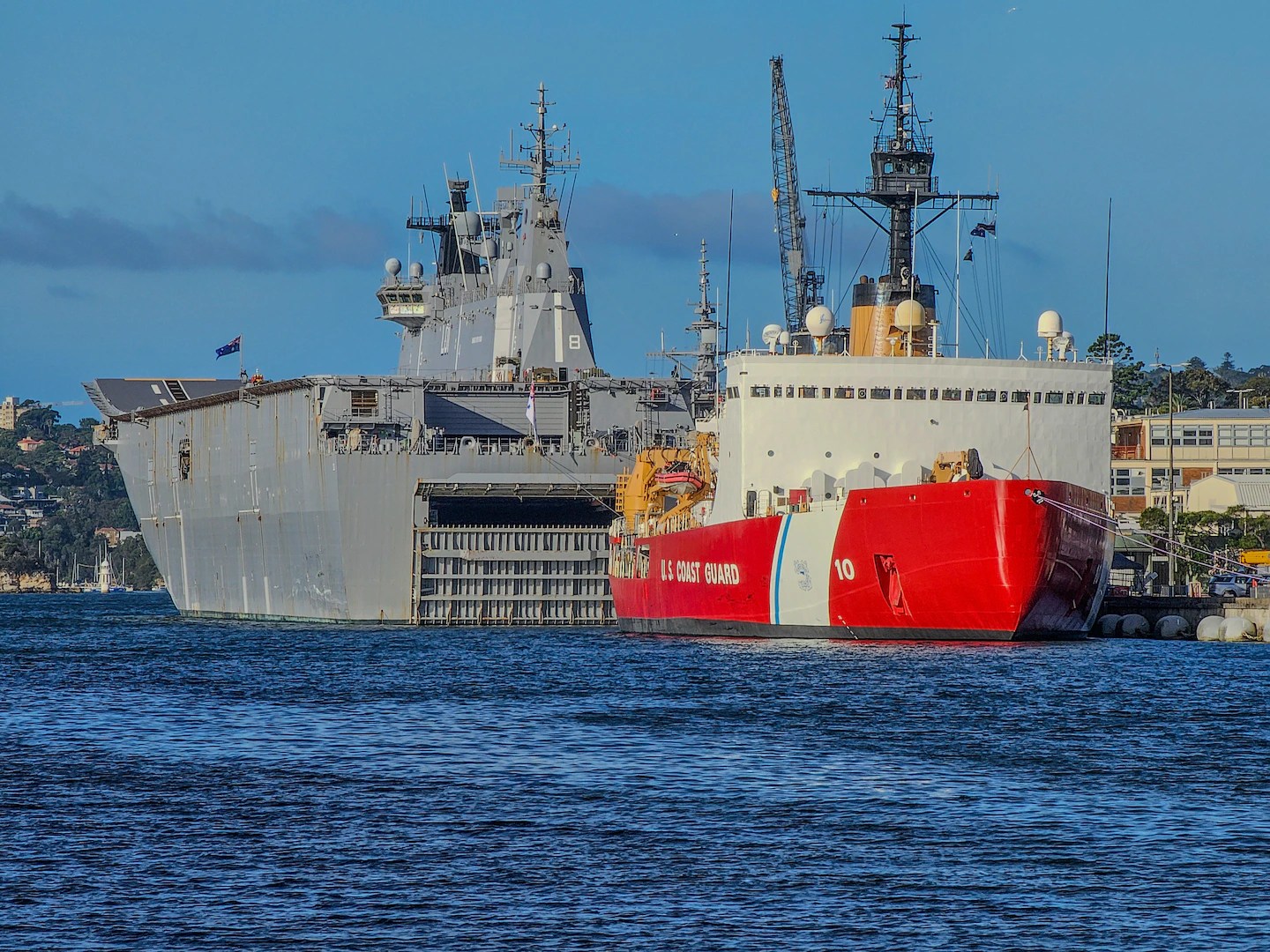
USCGC Polar Star moored in Australia, presumably at HMAS Kuttabul, in Sidney. The large vessel in the background is a Canberra class LHD, HMAS Adelaide (L01) I believe. While, with modifications, this two-ship class probably could operate F-35B VTOL fighters, I have seen no indication that they intend to do so. 

Just passing along this news release from Coast Guard News. More photos there. 


Dec. 21, 2023

U.S. Coast Guard Cutter Polar Star departs Australia, en route to Antarctica

Editor’s Note: To follow the U.S. Coast Guard Cutter Polar Star’s Operation Deep Freeze journey, click here for more imagery.

HOBART, Australia — U.S. Coast Guard Cutter Polar Star (WAGB 10) and crew departed Hobart, Wednesday, after a four-day port call in Hobart and an earlier stop in Sydney, to begin the journey across the Southern Ocean en route to Antarctica in support of Operation Deep Freeze 2024.

While in Hobart and Sydney, the crew hosted tours aboard the Polar Star for guests from the U.S. Embassy including U.S. Ambassador for Australia Caroline Kennedy and members from the Australian government, Royal Australian Navy, Tasmanian government, local industry partners, and local schools and universities.

“A sincere thank you to our Australian hosts and all our international partners whose incredible collaboration has defined the success of Operation Deep Freeze,” said Capt. Keith Ropella, commanding officer of Polar Star. “The cohesion among Antarctic programs reinforces the significance of our joint efforts, fostering a legacy of success for future scientific endeavors in this challenging environment.”

Operation Deep Freeze is a joint military service mission to resupply the United States Antarctic stations of the National Science Foundation, who is the lead agency for the United States Antarctic program (USAP). This year marks Polar Star’s 27th voyage to Antarctica. Every year, a joint and total force team work together to complete a successful Operation Deep Freeze season. Military members from the U.S. Air Force, Army, Coast Guard, and Navy work together through Joint Task Force-Support Forces Antarctica to continue the tradition of providing U.S. military support. Operation Deep Freeze works closely with other Antarctic programs to include those of Australia and New Zealand, as well as those Nations’ respective defense forces.

Leading up to and during the transit, the crew received training and prepared themselves to support this vital mission despite the austere environment. Operation Deep Freeze is one of the more challenging U.S. military peacetime missions due to the harsh environment in which it is conducted. Antarctica is the coldest, windiest, most inhospitable continent on the planet, and each trip requires careful planning and coordination.

“Through rigorous training and specialized preparations, our Coast Guard team stands ready for the challenges of Operation Deep Freeze,” said Lt. Cmdr. Don Rudnickas, operations officer of Polar Star. “The Coast Guard’s unwavering commitment underscores our dedication to the success of U.S. missions in the Polar Regions, ensuring the safety and efficacy of our operations.”

The Polar Star provides heavy icebreaking capabilities to facilitate sealift, seaport access, bulk fuel supply, and port cargo handling for three U.S. research stations in Antarctica with McMurdo Station being the largest. The cutter’s icebreaking capabilities enable the safe delivery of critical supplies to sustain USAP’s year-round operations and support international partnership in the harsh Antarctic environment. It’s vitally important that the U.S. maintains a maritime domain presence in Antarctica to protect uninhibited international access to the region.

When the Polar Star deploys in support of Operation Deep Freeze, they routinely spend the holiday season away from home. During the cutter’s first stop in Honolulu, the crew celebrated Thanksgiving while underway and moored alongside the U.S. Navy fleet at Joint Base Pearl Harbor-Hickam in Honolulu.

During the transit across the Pacific, the crew sailed through the position 0 degrees latitude and 180 degrees longitude, also known as “The X” marking the intersection of the equator and international date line. Crossing this exact position is a unique and rare opportunity among Coast Guard crews.

On December 10, the Polar Star moored at HMAS Kuttabul alongside several Royal Australian Navy ships close to the center of Sydney during a logistics stop for fuel and supplies.

The Polar Star departed its Seattle homeport November 15 and has traveled approximately 7,700 miles with stops in Honolulu, Sydney and Hobart.

The Polar Star is the United States’ only asset capable of providing access to both Polar Regions. It is a 399-foot heavy polar icebreaker commissioned in 1976, weighing 13,500 tons, 84-feet wide, with a 34-foot draft. The six diesel and three gas turbine engines produce up to 75,000 horsepower.

“NATO admiral warns of Chinese, Russian threat in Arctic” –The Watch

Map of the Arctic region showing shipping routes Northeast Passage, Northern Sea Route, and Northwest Passage, and bathymetry, Arctic Council, by Susie Harder

NORTHCOM’s online magazine, The Watch reports,

Adm. Rob Bauer, chair of NATO’s military committee … is concerned that the People’s Republic of China (PRC) will try to convert its current shipping through Russia’s Northern Sea Route into a military presence in the Arctic.

“We know there are military scientists on board these ships,” Adm. Rob Bauer, who chairs NATO’s military committee, told Bloomberg News on 21 October 2023. “They haven’t said they won’t go there militarily.”

The US does have a strong geographic position, in that it holds one side of the narrow Bering Strait through which any shipping (including submarines) using the direct route between the Pacific and the Arctic must pass.

The question remains, is the US strong enough to hold and exploit its geographic advantage in the event of a major conflict.


“Cutter Healy returns home after circumnavigating the globe” –MyCG

USCGC Healy (WAGB-20) and the Norwegian Coast Guard Vessel Svalbard sail in formation while en route to conduct joint exercises in northern Norway in the Barents Sea. US Coast Guard Photo

Below is a news release from MyCG.

Dec. 20, 2023

Cutter Healy returns home after circumnavigating the globe

By Senior Chief Petty Officer Charly Tautfest, U.S. Coast Guard Pacific Area

U.S. Coast Guard Cutter Healy (WAGB 20) and crew returned to its homeport Dec. 15, 2023, after circumnavigating the globe covering 25,000 miles in 159-days in support of the 2024 Arctic science missions.

The Healy and crew made port call stops in Seward and Kodiak, Alaska; Tromsø, Norway; Copenhagen, Denmark; Reykjavik, Iceland; Charleston, South Carolina; and Ft. Lauderdale, Florida. Additionally, Healy transited the Panama Canal on its return to Seattle.

“I am incredibly proud of the crew’s performance during our 159-day deployment,” said Capt. Michele Schallip, commanding officer of Healy. “The Healy continued demonstrating the nation’s commitment to the global science community as it seeks to improve understanding of the changing Arctic, particularly in ice-covered waters difficult to reach by most research vessels. This deployment also allowed for engagements and joint exercises with Canada, Norway, The Kingdom of Denmark, and Iceland, which promoted interoperability and cooperation in the Arctic region. The crew was able to share similarities and differences with crews of ships conducting similar work to Healy for their respective nations, a special opportunity to build on these long-standing partnerships.”

The cutter’s first mission supported the Office of Naval Research’s Arctic Mobile Observing System, deploying data collection buoys, subsurface gliders, and other sensors in ice-covered waters north of Alaska. The second mission was in collaboration with the National Oceanic and Atmospheric Administration and the National Science Foundation. Healy and scientists recovered and replaced subsurface moorings with oceanographic instruments and sensors as part of the Nansen and Amundsen Basins Observational System in the East Siberian and Laptev Seas. In addition, the cutter hosted a team from the Coast Guard Research and Development Center, who conducted a broad portfolio of research to develop better techniques and technologies for operating in the Arctic environment.

While deployed, Healy conducted crew exchanges with crews from the Canadian Coast Guard Ship Sir Wilfred Laurier and the Icelandic Coast Guard Vessel Thor. The cutter and crew participated in a similar exchange with the Norwegian Coast Guard Vessel Svalbard and crew before joining in a multi-agency search and rescue exercise in Norway. In addition to these valuable engagements with Arctic partners, the cutter visited port cities on the Atlantic coast of the United States, increasing awareness of U.S. Coast Guard missions in the Arctic.

Healy is the Coast Guard’s only icebreaker designed specifically to support research and the nation’s sole surface presence routinely operating in the Arctic Ocean. Commissioned in 1999, the Healy is one of two active polar icebreakers.

2023 Ships and Submarines of the US Navy –Infographic

Raytheon gives us an infographic of ships and submarines of the US Navy. You can load the full pdf. It is available at the bottom of this linked page that talks about the SPY-6 radars.

It may be somewhat misleading in that it includes ships that are not finished yet, like the Constellation class FFGs and vessels that have been decommissioned like the Cyclone class PCs.

Still, it may be useful.

Thanks to Tom for bringing this to my attention.

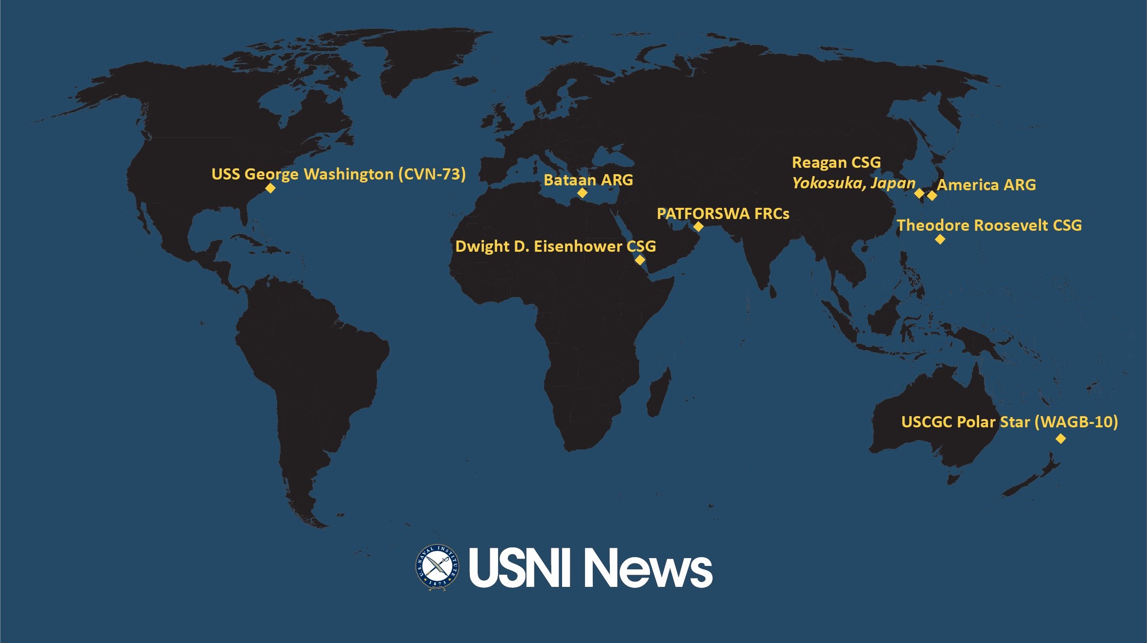
“USNI News Fleet and Marine Tracker: Dec. 11, 2023”

The latest USNI Fleet and Marine Tracker still does not include any indication of how many Navy ships are deployed to which fleets, but it does indicate that the Fleet is more active than usual with more than a third of the fleet deployed 109 out of 291 (37.5%) and more than the normal number of ships underway. Normally about a quarter are underway, but now 81 or 28% of the “battle force.” Not a huge jump but a noticeable increase.

Looks like USCGC Healey will be home for the holidays. Polar Star is down under.

“USCGC Healy (WAGB-20) is on its way to Seattle, Wash., expected to arrive on Dec. 18.”

“USCGC Polar Star (WAGB-10) arrived in Sydney, Australia on Dec. 9, 2023.” 

“Venezuela’s Border Dispute with Guyana Explained” –gCaptain

Orthographic map of Venezuela centered on Caracas Controlled territory in dark green. Claimed territory in light green.
From Wikipedia, author: Addicted04

gCaptain reports,

Tensions between neighbors Venezuela and Guyana have ratcheted up in recent weeks over a long-running territorial dispute.

At issue is a 160,000-square-km (62,000-square-mile) border territory around the Esequibo river, which is mostly jungle, and an offshore area where massive discoveries of oil and gas have been made.

The area in question has been recognized as part of Guyana since 1899, but Venezuela is making threatening noises. “A consortium by Exxon Mobil, China’s CNOOC and U.S. Hess began oil production in Guyana in 2019,” so the US has both economic and political interests in maintaining the status quo.

Since Coast Guard units routinely operate in the area and constitute the bulk of immediately available 4th Fleet assets, the Coast Guard may want to follow events there.

“The Long Blue Line: The loss of Morning Dew and genesis of Rescue 21” –MyCG

This is from MyCG. I am very proud that the Coast Guard did not simply say, “With as many calls as we get, it is inevitable that we will miss few.” Yes, we are human, but we can recognize and account for that. No call should go unanswered.

Dec. 8, 2023

The Long Blue Line: The loss of Morning Dew and genesis of Rescue 21

By Capt. W. Russell Webster (Ret.), United States Coast Guard

The Long Blue Line blog series has been publishing Coast Guard history essays for over 15 years. To access hundreds of these service stories, visit the Coast Guard Historian’s Office’s Long Blue Line online archives, located here: THE LONG BLUE LINE (uscg.mil) 

It was low tide in Charleston Harbor at 1:55 a.m. on Dec. 29, 1997 when 13-year-old Daniel Cornett’s anguished voice slashed the quietude of Coast Guard Group Charleston’s Watch Center:

“May … Mayday, U.S. Coast Guard, come in,” on Channel 16 (the distress channel) on VHF-FM marine radio.

The Sailing Vessel Morning Dew had just crashed into Charleston’s North Jetty. Daniel, his brother and cousin were jolted from a sound sleep. Daniel’s father, 49-year-old Michael Cornett, who had been steering the boat under engine power for the last eight hours, was ejected from the vessel, according to government reports.

At Coast Guard Group Charleston (later Sector Charleston), the regional maritime rescue headquarters, this particular four-second mayday radio call by the youngest Cornett family member was heard and automatically recorded by Stancil technology, a device designed to preserve critical radio messages. Unfortunately, the Coast Guard’s sole radio watchstander, a twenty-three-year-old petty officer, was 17-feet away from the radio console refilling his coffee mug as an otherwise quiet late-night shift drew on.

In his later testimony with the National Transportation Safety Board (NTSB), the petty officer said he heard only the tail end of the heavily garbled distress message, “U.S. Coast Guard, come in.” The radio watchstander had completed telecommunications school just a few months prior and only recently been qualified to stand watches without supervision. Despite what the NTSB would later call an extraordinary training program, he was unprepared for the circumstances that were about to unfold.

Following standard radiotelephone protocol, the watchstander responded fourteen seconds later: “Vessel calling Coast Guard, this is Coast Guard Group Charleston, over.” He then repeated his call using multiple radio transmission towers in different locations along the South Carolina shore. He also invited conversation on VHF-FM channel 16. But there would be no two-way interactive radio calls from the 34-foot sailboat Morning Dew on this fateful night.

Despite the odd time of night and prevailing weather conditions, the group’s radio watchstander quickly returned to the normal humdrum of off-season and late-night routine. This included monitoring as many as ten different frequencies that, during busy times, sometimes blared from an equal number of speakers mounted throughout the communications center. In the summer, radio watchstanders were constantly managing their time and involved in various conversations, often near simultaneously.

 Four minutes later, at 2:21 a.m., the crackle of an unintelligible burst of static was recorded on Group Charleston’s Stancil recorder. The watchstander, believing the earlier call and this one might be from the same source, again tried the radio without success. “Vessel calling Coast Guard, this is Coast Guard Group Charleston, over.” There was no response, and no log entries were made of the calls.

Given the state of the Coast Guard’s National Distress System network of VHF-FM near-shore system in late 1997, the Morning Dew’s only chance at this point in the distress would have been if the watchstander had been looking directly at the Direction-Finding equipment at the exact moment when the first distress call and the second follow-up static burst were heard. Even so, rewinding the tape and determining the word Mayday had been used would have only elevated awareness and mandated a call to his supervisor, the group duty officer (GDO) who was seeking authorized rest. Not hearing the initial word Mayday and theorizing a mariner was just testing his radio or the call had “skipped” from many miles away, and not following procedure to rewind the tape to conduct further investigation, the watchstander returned to other duties.

The radio watchstander would soon become involved with the Morning Dew again when he took a call from the local harbor pilot’s organization about four hours later, relaying a report from an inbound vessel of shouts being heard from the vicinity of Charleston Channel Buoy #22. He quickly relayed the information to his 17-year experienced GDO, who asked a pilot boat to investigate on behalf of the Coast Guard. Tragically, no additional assets were dispatched, and the GDO suspended further efforts before sunrise.

Around 11 a.m., tourists visiting from Atlanta would find bodies from the sailing vessel Morning Dew as two of the teenage boys washed ashore on a nearby beach. The Coast Guard then responded in full force, only to find a third body. Weeks later, the body of Morning Dew’s operator would wash ashore on a nearby island.

Within weeks, amid the growing hue and cry of the grieving family members, a major 18-month-long search and rescue analysis would be undertaken and begin to address difficult shortcomings in human behavior, procedures, and technology. Key gaps were the failings of the VHF-FM National Distress System (NDS) radio system, the backbone of the Coast Guard’s near-shore (20 miles) rescue communications system. Coast Guard Commandant James Loy would later go on to publicly speak about the Morning Dew case at a search and rescue conference entitled The Value of a Life. He would later say that, “there are two capstone issues that must be addressed by our service. There are issues of leadership and communications systems.”

 The original NDS in use for the Morning Dew case was built in the 1970’s, and was designed to provide Very High Frequency–Frequency Modulated (VHF-FM) radio coverage of 95,000 miles of coastline and connect mariners in distress to each other, point-to-point, and Coast Guard rescue services. After 25 years, the NDS’s problems were well known and documented in a Mission Needs Statement that, “formally acknowledged that a materiel solution is required to address the capability gaps.”

At the time of the Morning Dew case, there were as many as 68 known coverage areas where service was either poor quality or non-existent. The NDS was also supported by an antiquated tape-recording system that was both manually intensive and cumbersome. Additionally, the direction-finding system at the time had no recording capability. This meant that if a watchstander was not looking at the direction indicating compass rose at the time of the distress call and a different call came in, only the new call’s direction would be displayed.

According to Coast Guard sources, the Morning Dew case, “validated the need for a new VHF-FM system for the Coast Guard.”

The Morning Dew case was a collection of human and technological errors. Despite the original early morning call not having enough information to launch a rescue, the relatively junior Telecommunications Specialist failed to rewind the audio tape, make required log entries, or notify his supervisor. He also could not note the bearing of the call because he was recharging his coffee cup. Even if he had done all of that, the quality of the recording and in the insufficiency of locating information still might not have made a difference at that moment.

It would have, however, put rescuers on alert that they were dealing with an unresolved Mayday call, perhaps altering their response to the later cries heard from the Charleston channel area. The Coast Guard would eventually develop a new procedure in 2005 called, “range ring analysis” based on signal strength that could have provided a rough estimate of the caller’s position and a start point for a searchable area. But the Morning Dew case was in 1997.

Significant procedural changes would later be made. Among them, adding new watchstanders, always providing for at least three personnel on watch, on average. Additionally, experienced, permanent civilian search and rescue personnel would be provided in every sector for continuity and training purposes. Today’s watch centers still, however, feature a single communications operational specialist in a booth, but there are always more senior people around to discuss issues if there is any doubts about what to do.

The single most significant technological change the Coast Guard would make is the replacement of the NDS with the Rescue 21 (R21) near shore communication system. The system, an advanced command, control, and direction-finding communications system, was created to better locate mariners in distress and save lives and property at sea and on navigable rivers.

By harnessing state-of-the-market technology, Rescue 21 enables the Coast Guard to execute its search and rescue missions with greater agility and efficiency. Rescue 21 helps identify the location of callers in distress via towers which generate lines of bearing to the source of VHF radio transmissions reducing search time. It extends coverage to a minimum of 20 nautical miles from the coastline, improves information sharing and coordination with the Department of Homeland Security and other federal, state, and local first responders, and can also help watchstanders recognize potential hoax calls by identifying discrepancies between what a caller is reporting in distress and the actual transmission site, thus conserving, and reducing risk to valuable response resources.

 Relative to its predecessor systems, R21 can provide reliable and redundant capabilities to determine where some calls originate, rapid retrieval and position fixing, and ruling out the need for searches for obvious hoax callers. It also facilitates near shore distress cases in areas where the Coast Guard performs 90% of its rescues.

According to the Coast Guard’s Joe Ayd from the Office of C5I Capabilities, today’s Rescue 21 system implements, “the Coast Guard’s ability to receive VHF-DSC [Digital Selective Calling], which allows a vessel like the Morning Dew to simply press a button on their radio to [digitally] transmit a distress call and provide a position [if connected to the boat’s GPS] to the Coast Guard command center.” VHF-FM DSC took coastal rescue communications from a point-to-point system (distressed mariner – Coast Guard) to a virtual paging system where any boat receiving the DSC distress call is duty bound to digitally relay it to a Coast Guard shore rescue facility on behalf of the troubled mariner.

Ayd added that, “R21 made significant improvements to the ability of the watchstander to not only retrieve the audio of a call, but to also conduct some basic cleanup of the call to better understand what is being said through all the noise or garble.”

This means that an already busy Coast Guard watchstanders can economize on the effort to scan the recording within the confines of an already busy environment with the best chance of understanding the content of the call.

It took an 18-month exhaustive search and rescue system investigation, a 20/20 television expose and a $19.5 million-dollar civil judgment and more than two decades to complete R21 along U.S. coastlines and in Alaska’s remote and rugged areas. “The final tower in the Rescue 21 system was accepted in October 2017, completing a design and installation process spanning more than 20 years.”

The Coast Guard has made significant progress with the R21 VHF-FM system since the 1997 Morning Dew case. However, the venerable service faces new challenges and opportunities to improve near shore rescue communications. For example, over the last two years (Fiscal years 22 and 23), the Coast Guard has annually responded to between 15,000 and 16,000 calls for assistance with just over half being received by phone. During that same time, only between 1,200 and 1,500 rescues were initiated each year with radio notifications. Over the last decade, the number of rescue calls initiated by radio has declined while phone and other smart technology notifications have increased.

Captain Webster writes about contemporary Coast Guard rescues. Readers may contact him and access or order his published works, including Lost in Charleston’s Waves, detailing the Morning Dew tragedy, at https://www.wrussellwebster.com

“Personnel Shortage At U.S. Coast Guard Sinks 10 Cutters & 29 Stations” –What is Going on With Shipping?

Above is one of a series of “What is Going on With Shipping?” videos done by Salvatore Mercogliano. Most are not directly Coast Guard related, but this one is spot-on.

Additional Comment

We did talk about this earlier, “Coast Guard adjusts operations plan to mitigate 2024 workforce shortage” –MyCG 

It should be noted that this is not because we have reduced the number of afloat billets, it is because the workforce has not grown as rapidly as the number of billets.

Also, we are not greatly reducing the number of ships compared to historic numbers or the “Program of Record,” The program of record was to provide 8 NSCs, 25 OPCs and 58 FRCs for a total of 91. With these changes we will have 10 NSCs, 23 WMECs, and 55 to 57 FRCs for a total of 88-90 and up to 98 or more as all 65 FRCs currently funded are delivered.

The problems are that the 210s should have been replaced decades ago and demand for Coast Guard assets has increased. The Missions we are doing with the FRCs in the Western Pacific should really be being done by a ship with better seakeeping and endurance and facilities for a helo and UAS, something like “Cutter X.”

“All survive Coast Guard helicopter crash on island near Sitka” –Must Read Alaska

Must Read Alaska reports,

“A Coast Guard MH-60 Jayhawk helicopter air crew from Air Station Sitka crashed with four people aboard on Read Island during a search and rescue mission late Monday night. The crash took place while the helicopter crew was assisting a vessel that had taken on water.”

Thanks to David for bringing this to my attention.


Addition: Below is the a D17 News Release.


Nov. 14, 2023

Coast Guard helicopter crashes in Alaska during search and rescue response

D17 Public Affairs

JUNEAU, Alaska — A Coast Guard MH-60 Jayhawk helicopter air crew from Air Station Sitka crashed with four people aboard on Read Island during a search and rescue mission late Monday night.

Rescue crews from Alaska Wildlife Troopers and Petersburg Fire and Rescue arrived on scene at approximately 12:50 a.m., and a second MH-60 Jayhawk air crew from Air Station Sitka arrived at approximately 1:39 a.m. Together, they provided preliminary medical care to two crew members who were reported to have sustained serious injuries.

The four crew members were hoisted aboard the second Coast Guard helicopter and were transported to Petersburg for medical care. They were then transferred to Seattle via a C-130 Hercules aircraft from Coast Guard Air Station Kodiak for a higher level of care.

The watchstanders received notification of the crash at approximately 11:05 p.m. from the fishing vessel Lydia Marie, who was initially receiving search and rescue assistance from the aircrew due to flooding on their vessel.

“Our priority is to provide the highest level of care possible for our injured members and their families,” said Rear Adm. Megan Dean, commander of the Coast Guard’s 17th District. “We are grateful for the swift response and professional skill shown by the Alaska Wildlife Troopers and Petersburg Fire and Rescue members who answered our call for assistance during this critical time. We have opened an investigation into the cause of this event and will be forthcoming with the results as they become available.”

The U.S. Coast Guard Cutters Elderberry (WLI-65401) and Douglas Denman (WPC 1149) crews assumed responsibility for providing search and rescue assistance to the Lydia Marie and have established a security zone around the crash site.

The cause of the crash is currently under investigation.


An Update.


Nov. 14, 2023

Update 01: Coast Guard continues response to helicopter crash in Alaska during search and rescue case

D17 Public Affairs

JUNEAU, Alaska — Coast Guard crew members injured in the MH-60 Jayhawk helicopter crash Monday night on Read Island continue to receive medical care, and the search and rescue case for fishing vessel Lydia Marie is complete.

As of Tuesday afternoon, the four service members from Coast Guard Air Station Sitka involved in the crash were transported to the Harborview Medical Center in Seattle for a higher level of care via a C-130 Hercules aircraft from Coast Guard Air Station Kodiak.

The two Coast Guard members reported to have serious injuries were listed in serious condition, while the other two members were listed in good condition with minor injuries.

The crew of the U.S. Coast Guard Cutter Elderberry (WLI 65401) oversaw the de-watering of the fishing vessel Lydia Marie and escorted the vessel back to Petersburg. There, the crew of the U.S. Coast Guard Cutter Pike (WPB 87365) conducted a post-search and rescue boarding with no violations, closing the original search and rescue case.

On-scene weather at the beginning of the search and rescue evolution with the Lydia Marie was reported with wind speeds at 28-34 miles per hour and seas at four to five feet. Upon arrival at the scene of the crash, a second Coast Guard MH-60 rescue helicopter reported wind speeds of 46 miles per hour, visibility at one-quarter of a mile, and seas at one to two feet.

Four people were confirmed aboard the Lydia Marie, and their initial call for assistance was transmitted on VHF-FM channel 16 Monday night at approximately 8:06 p.m.

The investigation into the cause of the helicopter crash is ongoing.

Further requests for information by members of the media can be made by contacting the Public Affairs duty watchstander at D17-DG-PublicAffairs@uscg.mil.


Nov. 15, 2023

Update 02: Coast Guard continues investigation of helicopter crash, two released from hospital

D17 Public Affairs

JUNEAU, Alaska — Two Coast Guard crew members have been released from the hospital, and the investigation into the cause of an MH-60 Jayhawk helicopter air crew crash on Read Island continues, Wednesday morning. 

The remaining two crew members who were previously listed in serious condition have improved and are now listed in fair condition.

The investigation into the crash is still ongoing. 

“FarSounder joins Seabed 2030 in Mapping the World’s Oceans” –FarSounder News Release

Below is a news release from FarSounder. Sure, it’s a PR piece, but this is an interesting and potentially important project. For decades, Coast Guard cutters passed their depth sounding to the Hydrographic service. We have talked about FarSounder products before.

November 7, 2023
Warwick, RI USA

FarSounder joins Seabed 2030 in Mapping the World’s Oceans

FarSounder is partnering with The Nippon Foundation-GEBCO Seabed 2030 Project to work together to advance the collective understanding of the ocean floor in pursuit of the complete map of the entire seabed.

This partnership coincides with FarSounder’s recent Small Business Innovation Research (SBIR) Phase I grant awarded by the National Oceanic and Atmospheric Administration (NOAA). This award is providing funding for the research and development of a new project that will develop a cloud-based service to shareFarSounder/NSSL Global survey data collected by FarSounder customers.

The project – Enabling Expanded Crowdsourced Bathymetry Contributions With High-Quality Metadata via Commercially Sustainable Incentives to Contributors – will allow for data sharing with others across the FarSounder customer fleet and with Seabed 2030 via the International Hydrographic Organization’s (IHO) Data Centre for Digital Bathymetry (DCDB), which archives over 30 terabytes of oceanic depth soundings and serves as the long-term archive for Seabed 2030.

Seabed 2030 is a collaborative project between The Nippon Foundation and the General Bathymetric Chart of the Oceans (GEBCO), which seeks to inspire the complete mapping of the world’s ocean by 2030, and to compile all the data into the freely available GEBCO Ocean Map. The Project is formally endorsed as a Decade Action of the UN Ocean Decade. GEBCO is a joint programme of the IHO and the Intergovernmental Oceanographic Commission (IOC), and is the only organisation with a mandate to map the entire ocean floor.

“Our commitment to contributing high-resolution data to the IHO’s DCDB aligns seamlessly with Seabed 2030’s mission of achieving a complete map of the entire ocean floor,” commented FarSounder CEO Matthew Zimmerman. “By streamlining the transfer of data from customers to the DCDB we hope to encourage broader participation, inviting more individuals to actively contribute to bridging the gaps in our understanding of the ocean.”

“It’s a pleasure to welcome FarSounder on board as an official partner,” said Seabed 2030 Project Director Jamie McMichael-Phillips. “FarSounder plays a central role in championing crowdsourced bathymetry – which is essential to Seabed 2030. We look forward to working together, and look forward to following the company’s journey as it embarks upon its exciting new project.”

All data collected and shared with the Seabed 2030 project is included in the free and publicly available GEBCO global grid.

About FarSounder

At FarSounder, we believe in pushing the boundaries of what is possible in the exploration of the world’s oceans and waterways. We do this by developing innovative products that do more than just help vessels get safely from point A to point B. We make a difference by being environmentally conscious by creating products that reduce the impact on the ecosystem.

For over 20 years, we have dedicated ourselves to tackling new ideas and developing 3D Forward Looking Navigation Sonar technology (3D FLS). Our unique patented technology paints a clear picture of what lies ahead underwater and along the bottom, reducing the likelihood of collisions, which in turn prevents costly damage to property, the environment, and marine and human lives alike.

Our navigation systems are globally recognized. The Argos 1000, Argos 500, and Argos 350 are able to provide customers with a whole suite of sophisticated navigation capabilities of interest to many types of vessels. Wherever you decide to go, FarSounder will help get you there safely.

For more information, visit http://www.farsounder.com

About The Nippon Foundation-GEBCO Seabed 2030 Project

The Nippon Foundation-GEBCO Seabed 2030 Project is a collaborative project between The Nippon Foundation and GEBCO. The Seabed 2030 Project, launched at the United Nations Ocean Conference in 2017 by Chairman Sasakawa of The Nippon Foundation, coordinates and oversees the sourcing and compilation of bathymetric data from different parts of the world’s ocean through its five centres into the freely-available GEBCO Grid. Four Regional Centres cover the Southern Ocean, the Arctic and North Pacific Ocean, the Atlantic and Indian Oceans, and the South and West Pacific Ocean. These feed data products into the Global Data Centre. The IHO Data Center for Digital Bathymetry (DCDB) serves as the
long-term archive for Seabed 2030.
Find out more about the project and how to get involved.

For more detailed information on The Nippon Foundation-GEBCO Seabed 2030 Project, please visit our website, seabed2030.org, like our Facebook page, follow us on Twitter @Seabed2030, or contact enquiries@seabed2030.org.

For media inquiries, contact:
Pegah Souri
pegah.souri@shearwater.global
+44 (0)7951 581707

Media Contact:

Cassie Stetkiewicz
Director of Operations
Cassie.stetkiewicz@farsounder.com
+1 401 784 6700 6002