China Acknowledges Building Cutter to be Upgraded to Frigate in Crisis

type818ccgc

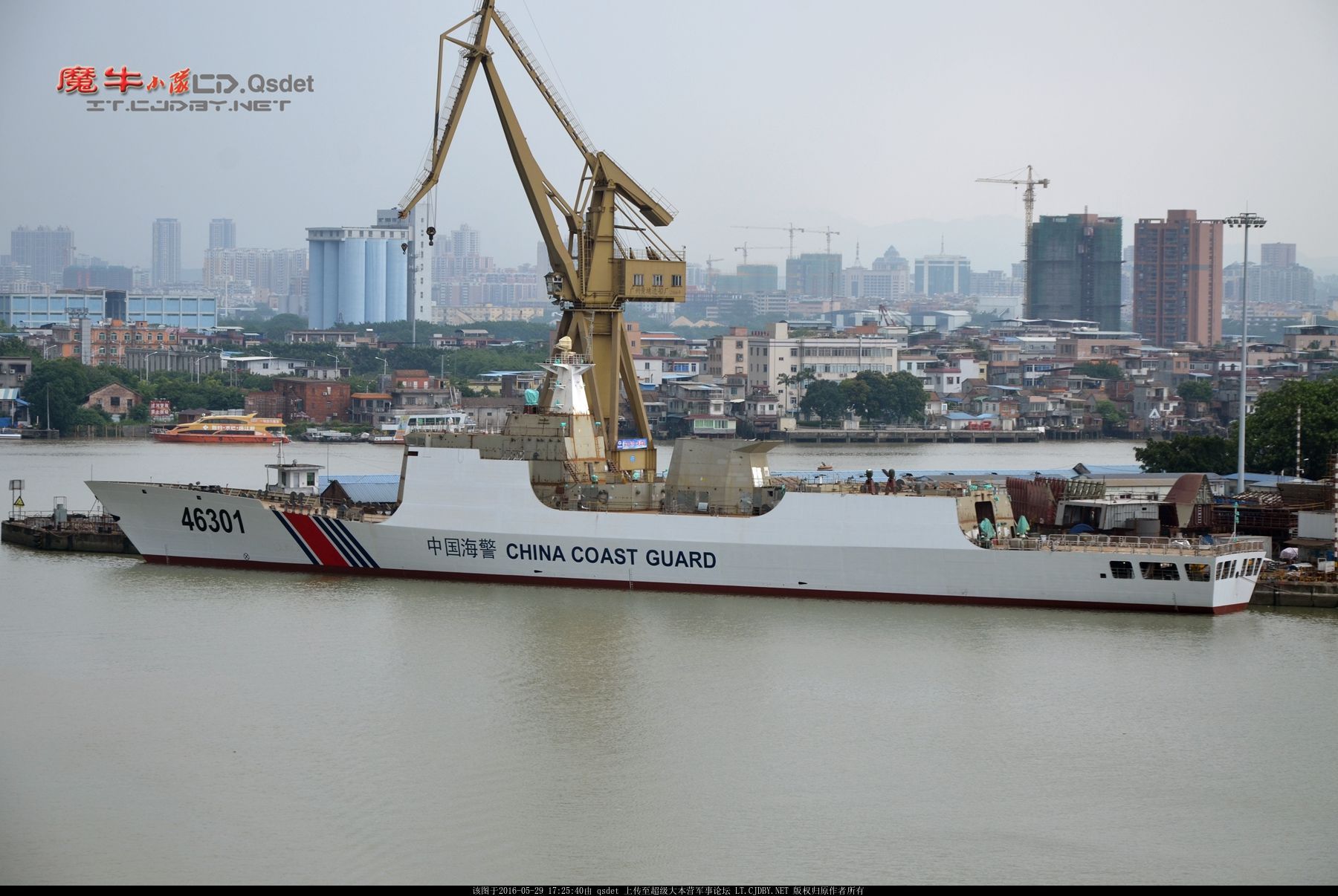
The National Interest reports that the Chinese have openly acknowledged that their newest Coast Guard cutter is being built with provision for upgrading to frigate status should a need arise.

Moreover they were apparently influenced by the example of the USCG during WWII.

In the same issue of this magazine, published by the major Chinese shipbuilding conglomerate China State Shipbuilding Corporation (CSSC), builder of the Type 818, there is not coincidentally a very detailed article about U.S. Coast Guard cutters in combat during the Second World War. That article explains that both USCGC Campbell and also USCGC Spencer were able to sink German U-boats (U-606 and U-175 respectively) during the pivotal Battle of the Atlantic. Most of the article examines the operations of 10 American USCG cutters that were 76.2 meters in length and built between 1928 and 1932. These ships were transferred to the hard pressed Royal Navy (RN) during 1941-42 and achieved an enviable war record in RN service, sinking both U-522 and U-954 – the latter with Germany Navy Commander Karl Donitz’s son aboard. The analysis notes that, according to UK naval records, the American cutters were viewed so favorably as to be rated as “surpassing each kind of comparable British designed frigate.” These ships are labeled as an “ideal anti-submarine escort ship” [理想的反潜护航舰] and the implications for the CCG going forward are obvious.

They actually sold the cutters a bit short. The 327s actually sank at least three and probably four U-boats and the ten 76.2 meter cutters, the 250 foot Lake Class, sank three submarines (two U-boats and an Italian). Six subs sunk by 17 ships may not sound particularly impressive, but in fact by comparison, it was spectacular.

The new Type 818 cutters are based on the Type 054 frigates. Its not too much of a stretch to expect them to be upgunned with the same weapons found on the “parent craft,” but if the time ever comes, there may be better systems available for upgrading the cutters or they might be given different capabilities to support emerging missions. That can be an advantage of having ships with unused upgadability.

The Type 054 are only slightly smaller than the Bertholf class, displacement 4,053 tons full load, length 134.1 m (440 ft), beam 16 m (52 ft), 30,400 HP, 27 knots, compared to the Bertholf’s 4,500 tons, 127.4 m (418 ft), 16.46 m (54 ft), 49,875 HP, and 28 knots. They actually appear to be the same size as the Offshore Patrol Cutters, but their design leans more toward higher speed. Their range is not as great as the OPC at about 8,000 miles compared to the OPCs’ 10,200, but it is a greater range than USN frigates enjoyed.

The Chinese have learned a lesson from USCG experience in World War II. I wonder if it is a lesson we may have forgotten.

Thanks to Luke for bringing this to my attention. 

White Hulls Must Prepare for Gray Zone Challenges–USNI

The US Naval Institute’s 2016 Coast Guard Essay Contest winner, “White Hulls Must Prepare for Gray Zone Challenges,” by LCdr.Craig Allen, Jr., USCG is worth the read.

Much of the focus is on the PATFORSWA and LCdr Allen seems to know where of he speaks.

“Lieutenant Commander Allen is a cutterman assigned to the Office of Defense Operations at Coast Guard Headquarters. He previously commanded the Sentinel-class cutter USCGC William Flores (WPC-1103) and the USCGC Baranof (WPB-1318), an Island-class cutter forward deployed to Manama, Bahrain. He also served as the executive officer of the USCGC Tornado (WPC-14), a Cyclone-class patrol craft. Commander Allen is a 2014 graduate of the U.S. Marine Corps Command and Staff College.”

But as he points out. These “Gray Zones” are not limited to SW Asia. We see them in South East Asia, East Africa, West Africa, and even in Central and South America.

While the post concentrates on crew preparation, I think its appropriate to point out an observation by Vice Adm. Joseph Mulloy, deputy chief of naval operations for integration of capabilities and resources, that attacks like those on the USS Mason, where a non-state actor employed cruise missiles are likely to become more common.

Maybe adding a CIWS (preferably the SeaRAM) to the OPC might not be a bad idea.

Greatly Expanded Marine National Monument around NW Hawaiian Islands

papahanaumokuakea-marine-national-monument

Click on the chart to see enlarged

I’m a bit late picking up on this but,

On Friday, August 26, 2016, President Obama signed a proclamation expanding the Papahānaumokuākea Marine National Monument. Previously the largest contiguous fully-protected conservation area in the United States at 139,797 square miles (362,073 km2), the expanded boundaries make it once again the biggest protected area on the planet at 582,578 square miles (1,508,870 km2) (439,916 sq nm–Chuck), nearly the size of the Gulf of Mexico.

“Papahānaumokuākea is globally recognized for its biological and cultural significance, being the only mixed UNESCO World Heritage site in the United States and only one of 35 mixed sites in the world. Its long list of protections includes designation as a Particularly Sensitive Sea Area by the International Maritime Organization. See full list of protections here.

This was before announcement of the slightly larger Marine Protected Areas recently announced in the Ross Sea off Antarctica (1,550,000 sq km or 451,908 sq nmiles). It is in addition to the recently expanded Pacific Remote Islands Marine National Monument (approximately 1,269,090 sq km or 370,007 sq nm).

My question regarding how these sanctuaries will be enforced remains.

World’s Largest Marine Protected Area Established in the Ross Sea (Antarctica)

512px-Antarctica_CIA_svg

A Marine Protected Area (MPA) has been established in the Ross Sea off Antarctica and South of New Zealand. The area is very large, 1.55M sq kM, the largest Marine Protected Area in the world. That is about the same size as the US East Coast EEZ, larger than the West Coast EEZ and 72% of it is no take area.

We have seen that New Zealand has been doing fisheries patrols off Antarctica, but they only have two Offshore Patrol Vessels. Who is going to enforce these new restrictions? There seem to be many areas where regulations are imposed, but enforcement is inadequate or non-existent.

I am quoting the Commission for the Conservation of Antarctic Marine Living Resources (CCAMLR) news release in full below:

The world’s experts on Antarctic marine conservation have agreed to establish a marine protected area (MPA) in Antarctica’s Ross Sea.

This week at the Meeting of the Commission for the Conservation of Antarctic Marine Living Resources (CCAMLR) in Hobart, Australia, all Member countries have agreed to a joint USA/New Zealand proposal to establish a 1.55 million km2area of the Ross Sea with special protection from human activities.

This new MPA, to come into force in December 2017, will limit, or entirely prohibit, certain activities in order to meet specific conservation, habitat protection, ecosystem monitoring and fisheries management objectives. Seventy-two percent of the MPA will be a ‘no-take’ zone, which forbids all fishing, while other sections will permit some harvesting of fish and krill for scientific research.

CCAMLR Executive Secretary, Andrew Wright, is excited by this achievement and acknowledges that the decision has been several years in the making.

“This has been an incredibly complex negotiation which has required a number of Member countries bringing their hopes and concerns to the table at six annual CCAMLR meetings as well as at intersessional workshops.

“A number of details regarding the MPA are yet to be finalised but the establishment of the protected zone is in no doubt and we are incredibly proud to have reached this point,” said Mr Wright.

CCAMLR’s Scientific Committee first endorsed the scientific basis for proposals for the Ross Sea region put forward by the USA and New Zealand in 2011. It invited the Commission to consider the proposals and provide guidance on how they could be progressed. Each year from 2012 to 2015 the proposal was refined in terms of the scientific data to support the proposal as well as the specific details such as exact location of the boundaries of the MPA. Details of implementation of the MPA will be negotiated through the development of a specific monitoring and assessment plan. The delegations of New Zealand and the USA will facilitate this process.

This year’s decision to establish a Ross Sea MPA follows CCAMLR’s establishment, in 2009, of the world’s first high-seas MPA, the South Orkney Islands southern shelf MPA, a region covering 94 000 km2 in the south Atlantic.

“This decision represents an almost unprecedented level of international cooperation regarding a large marine ecosystem comprising important benthic and pelagic habitats,” said Mr Wright.

“It has been well worth the wait because there is now agreement among all Members that this is the right thing to do and they will all work towards the MPA’s successful implementation,” he said.

MPAs aim to provide protection to marine species, biodiversity, habitat, foraging and nursery areas, as well as to preserve historical and cultural sites. MPAs can assist in rebuilding fish stocks, supporting ecosystem processes, monitoring ecosystem change and sustaining biological diversity.

Areas closed to fishing, or in which fishing activities are restricted, can be used by scientists to compare with areas that are open to fishing. This enables scientists to research the relative impacts of fishing and other changes, such as those arising from climate change. This can help our understanding of the range of variables affecting the overall status and health of marine ecosystems.

ViDAR Test

ViDAR is a high resolution, large area, computer aided, optical search system we looked at earlier. Reportedly the CG tested this system in 2014.

Sentient demonstrates ViDAR optical radar to the US Coast Guard

The following is a press release from ViDAR’s developer Sentient Vision Systems recporting a recent test done with the Coast Guard.

Melbourne, Australia, 29 September, 2016

Sentient today announced the successful completion of its live demonstration of ViDAR with the US Coast Guard. The trial was conducted off Cape Cod, MA, over a week with a team from the USCG Research and Development Centre, Hood Technologies and TacAero. The demonstration highlighted ViDAR’s capability to find objects of interest at great distance, whilst searching over wide tracts of ocean from a small UAS.

The demonstration was part of the Coast Guard’s continuing evaluation of small UAS technologies and sensors currently available in the commercial market.

“Detection is critical to bringing reliability to the surveillance task. With limited size and power, small and tactical UAS are heavily constrained in what they can carry and are often therefore limited to observing what has already been found” said Simon Olsen, Sentient’s Director of Business Development, Strategy and Partnerships.  “ViDAR is the first technology with the ability to conduct wide area search from a small/tactical UAS”

The US Coast Guard demonstration of ViDAR involved an exhaustive series of search flights designed to find vessels and objects representative of Coast Guard missions. The targets were placed in the search area at locations unknown to the ViDAR operator.

Highlights from the demonstration include ViDAR successfully, and autonomously, detecting a fast boat at 17.7nm, a life raft at 3.7nm, a person in the water at 1.9nm and a shipping vessel at over 33nm. Each time ViDAR detected an object, a small image was sent to the ground automatically; allowing the operator to move from initial detection, to classification and identification in seconds.

ViDAR comprises a high-resolution digital camera that continuously scans the ocean in a 180-degree arc in front of the air vehicle. The ViDAR software autonomously detects any object on the surface of the ocean, providing the ground control station with an image and location coordinate of each object detected in real time. The zoom-able spotter sensor can then be cross-cued to the object for closer inspection, while ViDAR continues to provide ongoing situational awareness.

Operating in effect like an optical radar, ViDAR enables a wide field of view, resulting in over 80 times ocean coverage compared with existing optics.

Looks like this system has been used on Scan Eagle. Recently the Coast Guard signed its first contract to provide a Scan Eagle for operation from USCGC Stratton. The Coast Guard has been hesitant to employ UAVs that did not have radars because optical systems were not very good at search. But even radars are probably not very good at detecting semi-submersible. Perhaps this might actually be better.

If it works as advertised, hopefully see we will more of this system.

Mexico Using Drone to Protect Endangered Porpoise

The NZHerald reports,

“Mexican authorities have used drones to detect and catch six vessels fishing within an area where gill nets are banned to protect the endangered vaquita porpoise.”

all in the Gulf of California over a three day period. It is believed that only 60 of this species remain.

Would be nice to know what kind of drone they were using. I suspect it is probably a Scan Eagle.

Thanks to Mike R. for bringing this to my attention. 


Denmark Builds Innovative Multi-Purpose Ship (Buoy Tender/Oil Recovery)

Marine Log reports recognition of “OV Bøkfjord as the Danish Ship of the Year 2016.”

OV Bøkfjord is multifunctional with the ability to operate as both a buoy and beacon maintenance vessel on a daily basis, as well as an oil recovery vessel for Kystverket in Norway.

It is designed for fast response time and fitted with specialized equipment, i.e. surface oil skimmers and dedicated holding tanks, etc. The vessel has an advanced diesel-electric hybrid propulsion system integrated into the vessel’s compact design.

These little 144 foot (44 meter) ships, intended to operate off Northern Norway, have several interesting features.

“We’ve developed a complex ramp system allowing the vessel to approach smaller islands and also to use the ramps for dynamic positioning during repairs at sea. These, as well as oil sweepers, holding tanks, offshore crane etc., have been integrated in the design whilst also making space for a battery pack, as Kystverket wanted the vessel to have diesel-electric hybrid propulsion.”

Acquisition Update: Coast Guard Releases RFI For Polar Icebreaker Acquisition Program Schedule And Industry Studies

The following is a news release:

The Coast Guard released a request for information (RFI) for the polar icebreaker acquisition program today. The request seeks feedback on the program’s notional acquisition approach and schedule, and includes a draft statement of work for industry studies on heavy polar icebreaker technology risks, sustainability, producibility and affordability. The RFI can be found here.

The Coast Guard requests that respondents submit a plan of action and milestones for meeting the acquisition program schedule and identify risks and potential opportunities to accelerate the heavy polar icebreaker acquisition.

The RFI also includes a draft statement of work for future industry studies that will inform efforts to promote affordability and minimize risk.

The deadline to submit responses is Nov. 10, 2016, at 11:00 a.m. Eastern time.

Following the completion of the industry studies, the Coast Guard plans to release a request for proposals for detail design and construction of a heavy polar icebreaker in fiscal year 2018. The service plans to begin production activities in 2020.

For more information: Polar Icebreaker program page


ACTUV and TALONS–Cheaper High Tech

NavyRecognition reports that DARPA has tested a combination of two of their projects that we have previously discussed, the Active Continuous Trail Unmanned Vessel (ACTUV) and the Towed Airborne Lift of Naval Systems (TALONS). This is a bit of departure for the ACTUV since it is designed to track submarines, but it might be applicable to counter drug operations in the Eastern Pacific.

“TALONS’ surface-track radar extended its range by 500 percent—six times—compared to its range at sea level. Its electro-optical/infrared scanner doubled its observed discrimination range. The TALONS team plugged in a commercial handheld omnidirectional radio; that radio’s range more than tripled.”

SOUTHCOM has been advocating using his area of operations as a testing ground. Perhaps DARPA would like to try this in the drug Transit Zone.

This is potentially high tech like our computers and cell phones, works better, cost less.

“TALONS is part of DARPA’s Phase 1 research for Tern, a joint program between DARPA and the U.S. Navy’s Office of Naval Research (ONR). Now that at-sea demonstration is complete, DARPA is transitioning TALONS to the Navy.”

Wonder if it might fit on the Webber class WPCs? They are larger than the ACTUV.

Here is the DARPA news release.