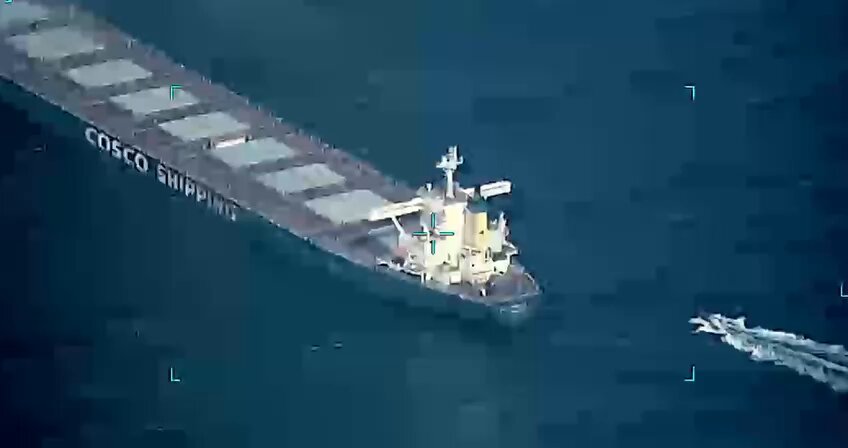
“Ecuador combats Chinese fleet’s illegal fishing with Canadian satellite technology” –Indo-Pacific Defense Forum

Indo-Pacific Defense Forum reports,

The Ecuadorian government is using Canadian technology to monitor the Chinese fleet’s illegal, unreported and unregulated (IUU) fishing around the Galápagos Islands.  In early June 2022, the government detected 180 Chinese vessels near the islands’ exclusive economic zone (EEZ), fishing for large Humboldt squid and threatening the region’s biodiversity and economy.

The Ecuadorian Navy patrols to prevent illicit fishing in the protected zone. “As long as these vessels are far from the insular EEZ, more than 100 miles [more than 160 kilometers] away, we monitor them by satellite,” Ecuadorian Navy Rear Adm. John Merlo León, commander of naval operations, told Ecuadorian television network Teleamazonas.

Reportedly, Ecuador uses both space technology company MDA, based in Brampton, Ontario, to provice satellite tracking, remote sensing and the ability to synthesize large amounts of data and Global Fishing Watch, a Google-backed website that tracks commercial fishing and interprets vessel movements, including fishing in prohibited areas.

“U.N. campaign targets illicit fishing” –Indo-Pacific Defense Forum

A picture taken on November 16, 2011 from a South Korean helicopter shows Chinese fishermen wielding sticks to stop an attack by South Korean coastguard commandoes armed with clubs aboard rubber boats during a crackdown on alleged illegal fishing in South Korean waters in the Yellow Sea off the southwestern coast county of Buan. South Korea’s coastguard mobilised 12 ships, four helicopters and commandoes for a special three-day crackdown on illegal fishing by Chinese boats this week. REPUBLIC OF KOREA OUT AFP PHOTO / DONG-A ILBO (Photo credit should read DONG-A ILBO/AFP/Getty Images)

The Indo-Pacific Defense Forum reports that today is the United Nations’ “International Day for the Fight Against Illegal, Unreported and Unregulated Fishing.”

The humanitarian and economic fallout of illicit fishing is significant in the Indo-Pacific and elsewhere. Each year it deprives the world’s oceans of 11 million to 26 million metric tons of fish and other seafood worth an estimated U.S. $10 billion to $23 billion.

IUU fishing accounts for 1 in 5 fish caught worldwide, the U.N. Food and Agriculture Organization (FAO) reports.

The short report provides an overview of the problem, identifies the Chinese fishing fleet and the most agrediuous perpetrator, and discusses what is being done to address the problem.

One of the recent steps taken is the Indo-Pacific Partnership for Maritime Domain Awareness (IPMDA) discussed here. Perhaps an additional step could be something like my proposal for a Combined Maritime Security Task Force.

“Obangame Express 2022 Promotes Cooperation To Fight Sea Crime” –ADF Magazine

Members of the U.S. Navy share critical care techniques with the Senegalese Navy during Obangame Express 2022. U.S. NAVY

I got a reminder that the Obangame Exercise 2022 had concluded (Brazil sent an OPV), so I went looking for some information about possible Coast Guard participation. I found none, although I feel sure at least some special teams were involved.

This report from AFRICOM’s African Defense Forum does include an interesting note,

One important element of the exercise is practicing the use of SeaVision, a maritime domain awareness tool that helps professionals in the operations center track vessels at sea. Created in 2012 by the U.S., this tool is used by about 25 African countries to monitor their waters.

Is this system system something the Coast Guard uses? Is it used by our friends in Latin America? SE Asia? Sounds interesting.

“Predicting illegal fishing activity is tip of the iceberg for mature AI technology” –BAE

BAE Systems technology applies machine learning analytics to automate low-level detection of activities of interest, such as fishing, from available data streams.

Below is a company press release, but it is an interesting one, with relevance to Coast Guard missions. The Obangame Express Exercise is one the Coast Guard has participated in, in the past. More info on the exercise here and here.


BAE Systems technology applies machine learning analytics to automate low-level detection of activities of interest, such as fishing, from available data streams.

The old “finding a needle in a haystack” analogy doesn’t begin to articulate the challenge associated with illegal fishing detection and identification. While a ship may be larger than a needle, the ocean is certainly larger than your biggest haystack. Add the need to not only find the ship, but determine its recent activities, anticipate future movements, and compare them with all other ships in the area — and do it in near real-time using open source data feeds.

At the Obangame Express event, which is the largest multinational maritime exercise in Western Africa, BAE Systems’ Multi-INT Analytics for Pattern Learning and Exploitation (MAPLE) as a Service, MaaS for short, was integrated with SeaVision, the U.S. Navy’s premier tool for unclassified interagency and coalition maritime data sharing. SeaVision is a maritime situational awareness tool that ingests maritime vessel position data from various government and commercial sources and simultaneously displays them on the same screen in a web browser.

“Military organizations use illegal fishing as a model application due to the unclassified nature of the available data,” said Neil Bomberger, chief scientist at BAE Systems’ FAST LabsTM research and development organization. “Successful detection of illegal fishing activity helps address a serious challenge and highlights another use case for our mature artificial intelligence technology.”

Giving depth to data

While manual analysis of individual vessel tracks is possible, it gets exponentially more challenging and time-consuming for large numbers of vessels. BAE Systems technology applies machine learning analytics to automate low-level detection of activities of interest, such as fishing, from available data streams. This enables analysts to quickly answer time-sensitive questions, prioritize manual data analysis activities, identify higher-level trends, and focus on decision-making instead of manual data analysis.

During the event, BAE Systems’ MaaS technology processed streaming data and automatically detected vessel behavior events that SeaVision displayed as an additional data layer to support user-friendly and timely analysis. The technology provides full visibility into the data to allow the users to check whether the detected behavior warrants further investigation. This helps build trust in the automation and supports additional analysis.

Decades in the making

BAE Systems’ FAST Labs maritime sensemaking capabilities are rooted in artificial intelligence and machine learning algorithms. Backed by nearly two decades of development, their behavior recognition and pattern analysis capabilities continue to show significant utility in real-world environments.

The cloud-based artificial intelligence technology was matured via work on the Geospatial Cloud Analytics (GCA) program. In the months since the successful event, the FAST Labs organization has continued to develop and mature its autonomy portfolio. Elements of its autonomy technology have proven successful in multiple domains including air, land, and sea.

“This successful event delivers on the promise of mature artificial intelligence technology – easy to integrate, incorporating trust, and providing fast and actionable information in a real-world scenario,” continued Bomberger. “The event showcased how our artificial intelligence technology can be deployed in a cloud environment, integrated with a government tool, and used to address relevant maritime activities.”

“Coast Guard issues warning to mariners turning off AIS” –D13 News Release

Below is a D13 news release. In addition to the normal law enforcement and SAR aspects of AIS use, It is also an essential element of our Maritime Domain Awareness efforts. When a contact is detected without AIS, we may have to make an identification. If we want to know what is approaching our ports, we need vessels to use AIS, so we don’t have to physically sight every vessel. 

united states coast guard

News Release

U.S. Coast Guard 13th District PA Detachment Astoria
Contact: Coast Guard PA Detachment Astoria
Office: (503) 861-6380
After Hours: (206) 819-9154
PA Detachment Astoria online newsroom

Coast Guard issues warning to mariners turning off AIS

Petty Officer 2nd Class Enrique Lemos operates in the surf near Winchester Bay, Oregon

Editors’ Note: Click on image to download high resolution version.

ASTORIA, Ore. — The Coast Guard is issuing a warning to mariners and commercial fisherman about the dangers and legal consequences of disabling a vessel’s Automated Identification System.

The Coast Guard has seen an alarming increase of commercial fishing and crabbing vessels disabling their AIS, purportedly in an attempt to keep their fishing spots secret from competition.

“AIS is a vital tool in a host of Coast Guard missions including Search and Rescue and Port Security,” said Lt. Collin Gruin, boarding team supervisor at Coast Guard Sector Columbia River. “It’s not only illegal to turn it off but also incredibly dangerous.”

AIS is a maritime navigation safety communications system adopted by the international community to help save lives and facilitate safe transit of navigable waterways.

AIS automatically transmits vessel information to shore stations, other ships, and aircraft. That includes vessel identity, type, position, course, speed, navigational status, and safety-related information.

The regulation (33 CFR 164.46) in part states that all self-propelled vessels, at a length of 65-feet or more, engaged in commercial service and operating on the Territorial Seas (within 12-nautical miles of shore) must maintain AIS in effective operating condition, which includes the continual operation of AIS and its associated devices (e.g., positioning system, gyro, converters, displays) at all times while the vessel is underway or at anchor, and, if moored, at least 15 minutes prior to getting underway. Effective operation condition also includes the accurate input and upkeep of all AIS data fields; an AIS encoding guide has been provided to facilitate complying with this requirement.

Violators of this regulation can expect to receive a civil penalty up to a maximum of $35,486 per violation.

“Crabbers may think that they are protecting their businesses, but they are actually making search and rescue efforts more difficult if an emergency happens at sea,” said Gruin.

“Bangladesh, U.S. and regional organizations discuss shared maritime domain awareness goals” –IndoPacificDefenseForum

A report from IndoPacificDefenseForum about an aspect of the CARAT exercise with Bangladesh, with emphasis on Maritime Domain Awareness and Illegal, Unregulated, Unreported fishing.

There is no mention of the Coast Guard, but you can be sure Coast Guardsmen were involved and the vessel, seen in the distance, in the accompanying photo (above) is a former USCG 378, BNS Somudra Avijan, the former USCGC Rush, one of two Hamilton class now serving in the Bangladesh Navy.

“Cooperative Maritime Law Enforcement and Overfishing in the South China Sea” –CIMSEC

Republic of Korea Coast Guard vessel #3006 in company with U.S. Coast Guard cutter USCGC Boutwell (WHEC-719) during the North Pacific Coast Guard Forum in August 2007. This forum was created to increase international maritime safety and security in the Northern Pacific Ocean and its borders. The Boutwell worked with the Korean coast guard while on their way to Yokosuka, Japan. The Japanese coast guard is one of the six nations involved in the forum.

CIMSEC brings us a discussion of the possibility of cooperative fisheries enforcement in the South China Sea to stop both overfishing and Illegal, Unregulated, Unreported (IUU) fishing and perhaps bring China into a more mutually beneficial relationship with her neighbors.

Earlier, I had a suggestion about how we might form an instrument of cooperative enforcement by forming a “Combined Maritime Security Task Force Pacific,” a law enforcement alliance rather than a military one.

Probably before that could be fully realized, the various nations with competing claims to the waters of the South China Sea, need to take their claims to the UN’s International Tribunal. The more nations use it, the more pressure on China to participate. If, they do not present a cases before the international their claims will be weakened.


Maritime Domain Awareness–Indian Style

Display of maritime traffic provided by AIS. Only vessels equipped with AIS are displayed, which excludes most fishing boats, pleasure craft, inland navigation and vessels less than 300 tons. Location: Dover Straits/English Channel. Author: fr:User:Pline

NavyRecognition provides some information on what India is doing to maintain Maritime Domain Awareness.

Since the 2008 terrorist attack on Mumbai, they have made a strong effort to monitor marine traffic. An earlier discussion and links to related topics here.

USCG Navigation Center: Steering a steady course for safe, secure, efficient waterways–MarineLink

The above screenshot shows the display of the virtual aid to navigation established in partnership between the U.S. Coast Guard and the U.S. Army Corps of Engineers on the Mississippi River. The virtual aid is significant in that it allows mariners to see a hazard when it is not possible to place a floating aid to mark it. U.S. Coast Guard image.

Marine Link has a very interesting post on the Coast Guard’s Navigation Center. It discusses its role in management of aids-to-navigation, issuance of Notice to Mariners, interface with NOAA and the Army Corps of Engineers, maintenance of GPS including ground based differential GPS equipment, Automatic Information System (AIS) monitoring and quality control, long range tracking of US flag merchant ships, and maintenance of a Maritime Domain Awareness within 1000 miles of the US.