“This company’s drone set flight-time records. But what it really wants is more work with the Pentagon” –Defense News

A Vanilla ultra endurance land-launched unmanned aerial vehicle (UAV) operates during U.S. Pacific Fleet’s Unmanned Systems Integrated Battle Problem (UxS IBP) 21 at Naval Base Ventura County, Point Mugu, on April 24, 2021. UxS IBP 21 integrates manned and unmanned capabilities into challenging operational scenarios to generate warfighting advantages. (MC2 Michael Schutt/U.S. Navy)

Defense News report,

WASHINGTON — Small business Platform Aerospace continued to set records in 2021 with its Vanilla Unmanned family of drones, but the company says it’s working to ensure it’s building a relevant warfighting platform, not just an aerospace novelty.

The Vanilla UAV in its long-endurance configuration set a world record in September and into October, when it flew for eight days, 50 minutes and 47 seconds out of Edwards Air Force Base in California. The aircraft had previously demonstrated a five-day flight.

We talked about this UAS, from veteran-owned small business Platform Aerospace, when it set the earlier record. Since then, there have been some significant developments including a drug interdiction capability test with SOUTHCOM.

“… in July with U.S. Southern Command. The vehicle flew out of Key West with a mesh radio, satellite communications, a radar pod and an electro-optical/infrared camera, demonstrating what a multi-day drone with a complex payload package could accomplish.”

There is also this mention of a sensor, that might be applied to other UAS, that could come in handy for icebreakers.

“While the bulk of Platform Aero’s work has been with the military, and chiefly the Navy, Pappianou said the aircraft flew a mission with a proprietary radar designed by the University of Kansas to measure snow and ice depths in the Arctic Circle.”

Two About Puma sUAS

Royal Navy Photo

Naval News reports on the Royal Navy’s increasing use of the Puma small Unmanned Air System (sUAS).

And we have this from Seapower, regarding a new night time imaging system.

The Puma is a system the Coast Guard has experimented with more than once, and the Canadians have also adopted it. My last look at this small UAS with comments on its suitability and links to previous posts here.

“Coast Guard drones can see underwater and inside vessels during response to hurricanes and extreme weather events” –MyCG

US Coast Guard Photo

US Coast Guard photo

These two photos which accompany the post appear to be of the same tank but taken from opposite sides. 

MyCG has as post about the increasing use of Unmanned Air Systems. In this case primarily concerning the use of small commercially available systems. Take a look.

Deploying Lifeboat, A New Capability for European Maritime Safety Agency Drones –Naval News

Naval News reports,

“TEKEVER has signed a new contract with the European Maritime Safety Agency for maritime surveillance by remotely piloted aircrafts. This innovative contract includes the deployment of lifeboats and many new sensors.”

I have to wonder if the capability is worth the trade-off? Most UAVs are weight constrained. To carry an inflatable boat would mean either less fuel or fewer sensors. Is this a capability that will be carried at all times, or is it an option to be loaded when needed? How often is this needed? Coast Guard aircraft frequently drop pumps, but I don’t remember hearing of their dropping life boats recently. In the European environment this may have something to do with the influx of migrants using unseaworthy craft.

The UAV they are using appears large in the photo, but it is actually smaller than the MQ-1 Predator. “The AR5 “has a maximum take-off weight of 180kg. It can reach a cruising speed of 100km/h with an endurance of 20 hours,” and has a SATCOM capability. A 20 hour endurance is good, but a 100 km/h (54 knot) cruise is relatively low.

On the other hand, they at least have a shore based UAS capability, something the US Coast Guard still does not have.

“BAE Systems Successfully Tests APKWS Laser-Guided Rockets Against UAS” –Seapower

An artist’s conception of an APKWS strike against an unmanned aircraft. BAE SYSTEMS

The Navy League’s on line magazine, Seapower, report the successful test of a new alternative for countering Unmanned Air Systems.

BAE Systems Inc. has successfully tested APKWS laser-guided rockets in precision strike tests against Class 2 unmanned aircraft systems at Yuma Proving Grounds, Arizona, the company said Oct. 11.

The 2.75-inch test rockets combined standard M151 warheads and Mk66 motors with APKWS precision guidance kits and a newly developed proximity fuze, enabling them to engage and destroy airborne drones at a fraction of the cost of traditional counter-UAS strike capabilities.

(A Class 2 UAS is 21 to 55 pounds, operates at 3500 ft or lower, and has a maximum speed of 250 knots, so its pretty small. ScanEagle is an example.)

As important as this cUAS capability may be, adding this capability to Coast Guard Units would also have the bonus of providing both a capability against a range of surface targets from small, fast, highly maneuverable craft to small ships, and at least a basic anti-aircraft capability.

Adding a launcher and the required laser designator to vessels with Mk 38 mod2/3 gun mounts should not be too difficult. The PATFORSWASIA Webber class FRCs would a good place to prototype an installation.

More on APKWS here:

“Airbus showcases DeckFinder technology during COMPASS2020” –NavyRecognition

Original caption, “When landing on small or moving helidecks, a difference of a few centimeters can compromise and endanger a whole mission. To avoid such risk, DeckFinder provides a 3-dimensional image of the RPASs relative position, aiding in landing the aerial vehicle safely (Picture source: Airbus)”

NavyRecognition reports on an interesting innovation for landing Vertical Take-off and Landing (VTOL) aircraft, manned or unmanned, on small moving platforms.

“DeckFinder is a local positioning system that lets manned and remotely piloted aerial vehicles (RPAS) determine their relative position in the harshest environmental conditions. The independent navigation system contributes to easier and safer take-off and landing procedures in GPS-shaded environments that lack reference points or visual cues.”

The maximum range is relatively short, “up to 300 metres,” but the claimed precision is high, “positioning accuracy of more than 20 cm,” about 8 inches.

“DeckFinder excels at aiding rotorcraft landings on moving ship decks, as during offshore operations. For landings involving a pitching and rolling ship deck, DeckFinder’s system of reference points integrated on the ship deck itself provides a crucial advantage to safe navigation.”

Such a system might allow us to operate VTOL UAS from the Webber class.


“Coast Guard Booth Presentations at Sea Air Space 2021” –CG-9

22 meter saildrone Ocean Mapping UAS

The Acquisitions Directorate (CG-9) has provided media used in the Coast Guard’s presentation booths at Sea Air Space 2021, August 2 and 3. While certainly not a substitute for being there, they do provide insights into programs and concerns.

Coast Guard Booth Presentations at Sea Air Space 2021

  • Blue Technology Center of Expertise (BTCOE)
    Overview Blue Technology Center of Expertise presentation
    Ms. Jennifer Ibaven and Dr. Peter Vandeventer, BTCOE Program Managers, Office of Research, Development, Test & Evaluation and Innovation (CG-926)
    Tuesday, Aug. 3, 2021, 3-3:30p.m.
  • Coast Guard Detachment at DOD’s Defense Innovation Unit
    DIU & USCG Overview presentation
    Cmdr. Michael Nordhausen, Liaison Officer to Defense Innovation Unit
    Tuesday, Aug. 3, 2021, 4-4:30p.m.
  • Unmanned Systems
    U.S. Coast Guard Unmanned Systems presentation
    Capt. Thom Remmers, Assistant Commandant for Capabilities Unmanned Systems Cross-Functional Team Lead
    Monday, Aug. 2, 2021, 2:30-3p.m.
  • The Future of the Arctic
    U.S. Coast Guard Arctic Policy presentation
    Mr. Shannon Jenkins, Senior Arctic Policy Advisor
    Tuesday, Aug. 3, 2021, 11-11:30a.m.
  • Illegal, Unreported and Unregulated Fishing
    U.S Coast Guard IUU Fishing Strategic Outlook presentation
    Cmdr. James Binniker, Office of Law Enforcement Policy, Living Marine Resources and Marine Protected Resources Enforcement Division
    Tuesday, Aug. 3, 2021, 2:30-3p.m.

“GA-ASI Flies MQ-9 in the Canadian Arctic” –Seapower

General Atomics Aeronautical Systems’ MQ-9A “Big Wing” UAS flew in the hostile climate of the Canadian Arctic. GA-ASI

The Navy League’s Seapower website reports,

 In a flight that originated from its Flight Test and Training Center (FTTC) near Grand Forks, North Dakota, General Atomics Aeronautical Systems, Inc. (GA-ASI) flew a company-owned MQ-9A “Big Wing” configured unmanned aircraft system north through Canadian airspace past the 78th parallel, the company said in a Sept. 10 release.

A traditional limitation of long-endurance UAS has been their inability to operate at extreme northern (and southern) latitudes, as many legacy SATCOM datalinks can become less reliable above the Arctic (or below the Antarctic) Circle – approximately 66 degrees north. At those latitudes, the low-look angle to geostationary Ku-band satellites begins to compromise the link. GA-ASI has demonstrated a new capability for effective ISR operations by performing a loiter at 78.31° North, using Inmarsat’s L-band Airborne ISR Service (LAISR).

The 78th parallel lies more than 1200 nautical miles North of Kodiak. Getting any kind of air recon that far north, other than perhaps icebreaker based helicopters, has always been difficult.

Even our icebreakers have difficulty communicating. Satellite coverage at these high latitudes is spotty at best.

The ability to operate UAS in this environment could substantially improve our Polar Domain Awareness and serve as a communications relay for multiunit operations in the Arctic or Antarctic.

The high altitude capability of these aircraft also provides a far larger view than would be possible from a helicopters. The horizon distance from 45,000 feet is about 250 nautical miles.

“Navy Arming Surface Ships with Drone Repellent System” –USNI

USCGC Charles Moulthrope (WPC-1141) prior to departure for PATFORSWA

The US Naval Institute News Service has a short post about a system that will reportedly detect and if required jam the radio frequency signals that control small Unmanned Air Systems like the commercially available hobby drones and similar control systems that might be used on larger UAS.

We noted the presence of this or a similar system on the Webber class cutters being transferred to PATFORSWA in February.

While there are autopilots that allow drones to travel considerable distances to reach fixed geographic points, operating drones that lack autonomous targeting, against moving targets, typically require two radio frequencies, one the video link from the drone back to the operator and one to control the drone, from the operator back to the drone. Jamming either of the frequencies would probably disable the drone. Generally these frequencies are UHF or VHF, limited to line of sight.

Gunner’s Mate Kyle Mendenhall shows the Drone Restricted Access Using Known Electromagnetic Warfare (DRAKE) system aboard USS Kansas City (LCS-22) on Aug. 16, 2021. USNI News Photo

If you expand the photo of USCGC Charles Moulthrope above, you can see a similar system, with its two vertical antenna of different sizes, on the mast port side, slightly below and behind the port blue flashing light, and above and inboard of the small round fixed air search radar antenna.

“PteroDynamics Secures Contract with US Navy to Deliver Cargo VTOL Aircraft” –News Release

Below is a news release from PteroDynamics.

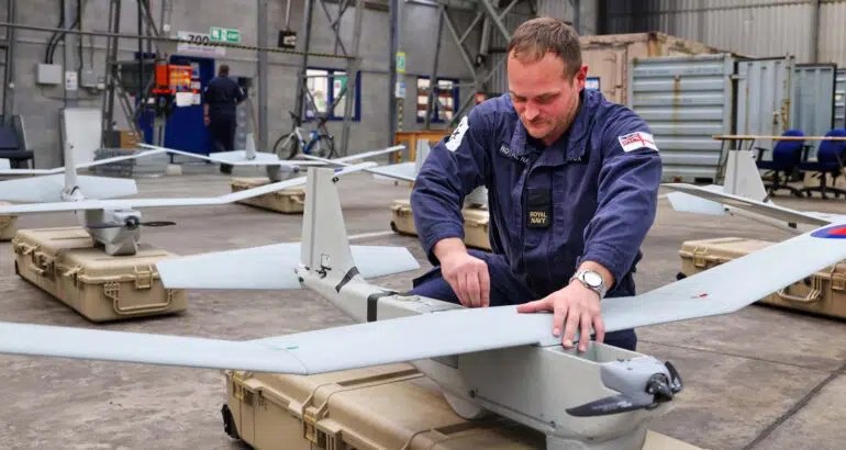
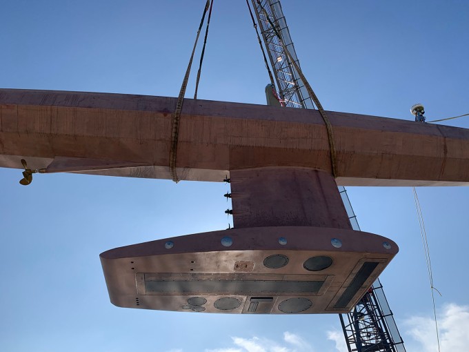
This looks like it might be an interesting aircraft type to operate from cutters. If it can carry cargo it can also carry sensors.

A small, unmanned version might provide patrol boats with search and identification capabilities currently available only to much larger cutters.

A larger version might replace helicopters while providing greater range and speed.

An even larger version, operating from shore or the largest cutters, might combine both search and rescue functions now provided by fixed wing search aircraft and rotary wing rescue aircraft. Combining those functions probably should be a long term Coast Guard objective. Not that the Coast Guard can fund manned aircraft development, but it seems likely the capability will be developed.

Apparently the Navy thinks the concept is promising enough to put at least some money into small prototypes.

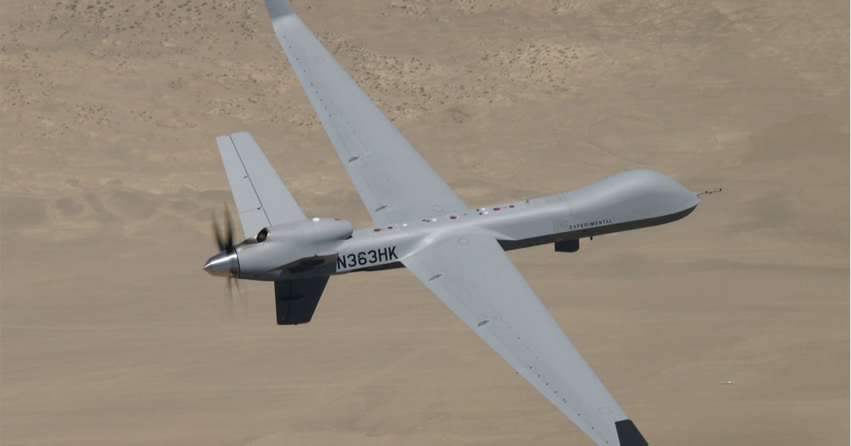
COLORADO SPRINGS, Colo.–PteroDynamics, an aircraft design and manufacturing company that develops innovative vertical take-off and landing (VTOL) aircraft, is today announcing it has secured a contract with Naval Air Warfare Center Aircraft Division (NAWCAD) to deliver 3 VTOL prototypes for the Blue Water Maritime Logistics UAS (BWUAS) program.

“Our design is well suited for operations on ships where windy conditions and tight spaces challenge other VTOL aircraft during takeoffs and landings.”

In 2018, Military Sealift Command and Fleet Forces Command identified a need for the United States Navy to develop a capability to autonomously deliver cargo with an unmanned aerial system (UAS) to and from ships at sea. Their analysis found that 90% of critical repair cargo delivered at sea by helicopters and V-22 aircraft weighed less than 50 pounds. A VTOL UAS can fill this critical need and free the manned aircraft to perform other higher priority missions.

“We are honored to be selected for this important project,” said Matthew Graczyk, PteroDynamics’ CEO. “This contract is the start of an important partnership, and we look forward to delivering the prototypes to NAWCAD.”

“This is an exciting milestone for our distinctive VTOL aircraft,” added Val Petrov, PhD, PteroDynamics’ founder and CTO. “Our design is well suited for operations on ships where windy conditions and tight spaces challenge other VTOL aircraft during takeoffs and landings.”

“Using unmanned, autonomous aircraft for delivery of these critical payloads is an important capability for the Navy to have,” said Blue Water’s project lead, Bill Macchione. “The innovative design of PteroDynamics offers significant potential for both military and civilian missions.”

About PteroDynamics

PteroDynamics is an aircraft design and manufacturing company that has developed a novel VTOL aircraft design that folds its wings during flight to transition between rotorcraft and fixed-wing configurations. Protected by three issued and five pending U.S. and international patents, Transwing® aircraft have improved controllability in takeoff and landing and typically require 1/3 of the ground footprint as compared to other aircraft with the same wingspan. Transwing®’s clean aerodynamic shape also allows it to fly faster and further than competitive designs. PteroDynamics is venture-backed by Kairos Ventures.

About NAWCAD

NAWCAD conducts research, development, test, evaluation, and sustainment for all United States Navy and United States Marine Corps aircraft and aircraft systems. Its diverse workforce of more than 10,000 military, civilian, and contractor engineers, scientists, testers, and other professionals support an evolving battlespace through research, development, test, and evaluation of both fielded and not-yet fielded naval and marine corps platforms and technology. Headquartered in Patuxent River, Maryland, the warfare center collaborates across its sites in St. Inigoes, Maryland; Lakehurst, New Jersey; and Orlando, Florida to ensure America’s warfighter always goes into conflict with significant advantage.

Contacts

Kayla Jones
Media@PteroDynamics.com